Lipiany geodata
Lipiany (West Pomerania) is a seat of a third-order administrative division; located in Poland in Europe/Warsaw (GMT+2) time zone. With population of 4,159 people, there are 786 cities with bigger population in this country. Compared to other cities in Poland, 83.6% of cities are located further ↓South; 98.2% of cities are located further →East and 91.3% of cities have higher elevation than Lipiany. Note1


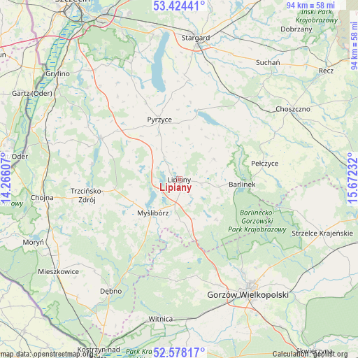
Lipiany GPS coordinates[2]
53° 0' 12.096" North, 14° 58' 9.084" East
| Map corner | latitude | longitude |
|---|---|---|
| Upper-left | 53.42441°, | 14.26607° |
| Center: | 53.00336°, | 14.96919° |
| Lower-right: | 52.57817°, | 15.67232° |
| Map W x H: | 94.1×94.1 km | = 58.5×58.5mi |
| max Lat: | 54.83135° ⇑16.4% North |
| Lipiany: | 53.00336° |
| min Lat: | ⇓83.6% South 49.21328° |
| min Long | Lipiany | max Long |
| 14.20249° | 14.96919° | 24.03723° |
| W 1.8%⇐ | ⇒98.2% E |
Elevation
Elevation of Lipiany is 69 m = 226 ft, and this is 122.4 m = 402 ft below average elevation for this country.
| Max E: |
974 m = 3196 ft | 91.3% |
| Avg. | 191.4 m = 628 ft | |
| Lipiany | 69 m = 226 ft | |
Min E: |
-3 m = -10 ft | 8.7% |
See also: Poland elevation on elevation.city.
Geographical zone
Lipiany is located in North temperate zone (between Tropic of Cancer and the Arctic Circle). Distance of this North polar circle is 1507.8 km =936.9 mi to North.| Distance of | km | miles | from Lipiany |
|---|---|---|---|
| North Pole | 4113.6 | 2556.1 | to North |
| Arctic Circle | 1507.8 | 936.9 | to North |
| Tropic Cancer | 3287.5 | 2042.8 | to South |
| Equator | 5893.4 | 3662 | to South |


Nearby cities:
15 places around Lipiany: (largest is in red/bold)
• Banie
23.2 km =14.4 mi,  297°
297°
• Barlinek
16.7 km =10.4 mi,  93°
93°
• Bielice
27.2 km =16.9 mi,  323°
323°
• Dolice
26 km =16.2 mi,  36°
36°
• Kozielice
15.1 km =9.4 mi, 319°
• Lubiszyn
24.8 km =15.4 mi,  183°
183°
• Mostkowo
6 km =3.7 mi,  101°
101°
• Myślibórz
11.1 km =6.9 mi,  217°
217°
• Nowogródek Pomorski
11 km =6.8 mi,  158°
158°
• Pełczyce
22.9 km =14.2 mi,  78°
78°
• Przelewice
13.3 km =8.3 mi,  32°
32°
• Pyrzyce
16.7 km =10.4 mi,  342°
342°
• Trzcinna
13.7 km =8.5 mi,  168°
168°
• Trzcińsko Zdrój
24.6 km =15.3 mi,  259°
259°
• Wysoka
25.6 km =15.9 mi, 169°
Sources, notices
• [Note1] Compared only with cities in Poland existing in our database
• [Src1] Map data: © OpenStreetMap contributors (CC-BY-SA)
• [Src2] Other city data from geonames.org with taken over terms of usage.
• [Src3] Geographical zone / Annual Mean Temperature by Robert A. Rohde @ Wikipedia
