Lubanowo geodata
Lubanowo (West Pomerania) is a populated place; located in Poland in Europe/Warsaw (GMT+2) time zone. With population of 990 people, there are 2509 cities with bigger population in this country. Compared to other cities in Poland, 85.3% of cities are located further ↓South; 99.4% of cities are located further →East and 92.7% of cities have higher elevation than Lubanowo. Note1


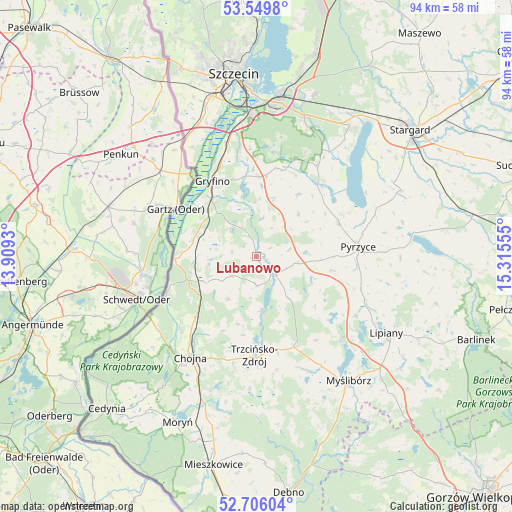
Lubanowo GPS coordinates[2]
53° 7' 47.964" North, 14° 36' 44.712" East
| Map corner | latitude | longitude |
|---|---|---|
| Upper-left | 53.5498°, | 13.9093° |
| Center: | 53.12999°, | 14.61242° |
| Lower-right: | 52.70604°, | 15.31555° |
| Map W x H: | 93.8×93.8 km | = 58.3×58.3mi |
| max Lat: | 54.83135° ⇑14.7% North |
| Lubanowo: | 53.12999° |
| min Lat: | ⇓85.3% South 49.21328° |
| min Long | Lubanowo | max Long |
| 14.20249° | 14.61242° | 24.03723° |
| W 0.6%⇐ | ⇒99.4% E |
Elevation
Elevation of Lubanowo is 61 m = 200 ft, and this is 130.4 m = 428 ft below average elevation for this country.
| Max E: |
974 m = 3196 ft | 92.7% |
| Avg. | 191.4 m = 628 ft | |
| Lubanowo | 61 m = 200 ft | |
Min E: |
-3 m = -10 ft | 7.3% |
See also: Poland elevation on elevation.city.
Geographical zone
Lubanowo is located in North temperate zone (between Tropic of Cancer and the Arctic Circle). Distance of this North polar circle is 1493.7 km =928.1 mi to North.| Distance of | km | miles | from Lubanowo |
|---|---|---|---|
| North Pole | 4099.6 | 2547.4 | to North |
| Arctic Circle | 1493.7 | 928.1 | to North |
| Tropic Cancer | 3301.6 | 2051.5 | to South |
| Equator | 5907.5 | 3670.7 | to South |


Nearby cities:
15 places around Lubanowo: (largest is in red/bold)
• Banie
4.7 km =2.9 mi,  134°
134°
• Bielice
11 km =6.8 mi,  44°
44°
• Chojna
22.2 km =13.8 mi,  213°
213°
• Gryfino
15.9 km =9.9 mi,  328°
328°
• Kobylanka
29.5 km =18.3 mi, 35°
• Kozielice
14.2 km =8.8 mi,  100°
100°
• Kołbaskowo
25.7 km =16 mi, 333°
• Lipiany
27.7 km =17.2 mi,  120°
120°
• Myślibórz
28.6 km =17.8 mi,  143°
143°
• Przecław
28.7 km =17.8 mi,  341°
341°
• Pyrzyce
18.8 km =11.7 mi,  84°
84°
• Stare Czarnowo
19.9 km =12.4 mi,  33°
33°
• Trzcińsko Zdrój
18.4 km =11.4 mi,  181°
181°
• Warnice
28.9 km =18 mi,  61°
61°
• Widuchowa
14.8 km =9.2 mi,  268°
268°
Sources, notices
• [Note1] Compared only with cities in Poland existing in our database
• [Src1] Map data: © OpenStreetMap contributors (CC-BY-SA)
• [Src2] Other city data from geonames.org with taken over terms of usage.
• [Src3] Geographical zone / Annual Mean Temperature by Robert A. Rohde @ Wikipedia
