Szlichtyngowa geodata
Szlichtyngowa (Lubusz) is a seat of a third-order administrative division; located in Poland in Europe/Warsaw (GMT+2) time zone. With population of 1,372 people, there are 2006 cities with bigger population in this country. Compared to other cities in Poland, 60.4% of cities are located further ↓South; 91.1% of cities are located further →East and 88.9% of cities have higher elevation than Szlichtyngowa. Note1


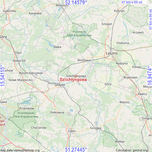
Szlichtyngowa GPS coordinates[2]
51° 42' 43.992" North, 16° 14' 39.372" East
| Map corner | latitude | longitude |
|---|---|---|
| Upper-left | 52.14579°, | 15.54115° |
| Center: | 51.71222°, | 16.24427° |
| Lower-right: | 51.27445°, | 16.9474° |
| Map W x H: | 96.9×96.9 km | = 60.2×60.2mi |
| max Lat: | 54.83135° ⇑39.6% North |
| Szlichtyngowa: | 51.71222° |
| min Lat: | ⇓60.4% South 49.21328° |
| min Long | Szlichtyngowa | max Long |
| 14.20249° | 16.24427° | 24.03723° |
| W 8.9%⇐ | ⇒91.1% E |
Elevation
Elevation of Szlichtyngowa is 79 m = 259 ft, and this is 112.4 m = 369 ft below average elevation for this country.
| Max E: |
974 m = 3196 ft | 88.9% |
| Avg. | 191.4 m = 628 ft | |
| Szlichtyngowa | 79 m = 259 ft | |
Min E: |
-3 m = -10 ft | 11.1% |
See also: Poland elevation on elevation.city.
Geographical zone
Szlichtyngowa is located in North temperate zone (between Tropic of Cancer and the Arctic Circle). Distance of this North polar circle is 1651.3 km =1026.1 mi to North.| Distance of | km | miles | from Szlichtyngowa |
|---|---|---|---|
| North Pole | 4257.2 | 2645.3 | to North |
| Arctic Circle | 1651.3 | 1026.1 | to North |
| Tropic Cancer | 3143.9 | 1953.5 | to South |
| Equator | 5749.9 | 3572.8 | to South |


Nearby cities:
15 places around Szlichtyngowa: (largest is in red/bold)
• Bielawy
22 km =13.7 mi,  286°
286°
• Brenno
23.5 km =14.6 mi,  355°
355°
• Chróścina
20.7 km =12.9 mi,  80°
80°
• Grębocice
13.7 km =8.5 mi,  202°
202°
• Góra
20.7 km =12.9 mi,  104°
104°
• Głogów
12.3 km =7.6 mi,  243°
243°
• Jerzmanowa
18.8 km =11.7 mi,  226°
226°
• Kotla
14.8 km =9.2 mi,  284°
284°
• Niechlów
8.9 km =5.5 mi,  107°
107°
• Rudna
22.5 km =14 mi,  176°
176°
• Sława
21.7 km =13.5 mi,  326°
326°
• Wijewo
23 km =14.3 mi,  349°
349°
• Wschowa
11.7 km =7.3 mi,  25°
25°
• Święciechowa
23.6 km =14.7 mi,  47°
47°
• Żukowice
18.5 km =11.5 mi,  256°
256°
Sources, notices
• [Note1] Compared only with cities in Poland existing in our database
• [Src1] Map data: © OpenStreetMap contributors (CC-BY-SA)
• [Src2] Other city data from geonames.org with taken over terms of usage.
• [Src3] Geographical zone / Annual Mean Temperature by Robert A. Rohde @ Wikipedia
