Rudna geodata
Rudna (Lower Silesia) is a populated place; located in Poland in Europe/Warsaw (GMT+2) time zone. With population of 1,619 people, there are 1744 cities with bigger population in this country. Compared to other cities in Poland, 56.5% of cities are located further ↓South; 90.9% of cities are located further →East and 73.1% of cities have higher elevation than Rudna. Note1


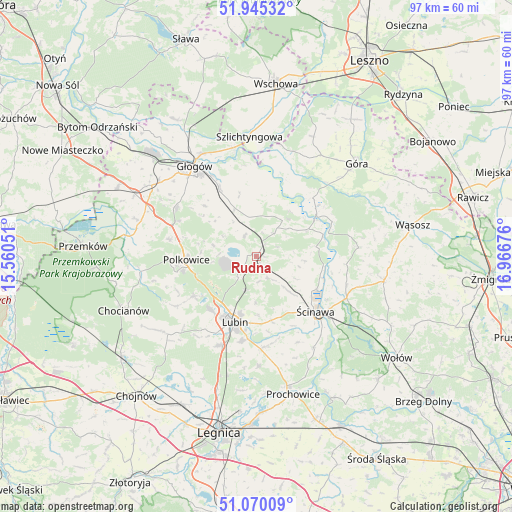
Rudna GPS coordinates[2]
51° 30' 35.316" North, 16° 15' 49.068" East
| Map corner | latitude | longitude |
|---|---|---|
| Upper-left | 51.94532°, | 15.56051° |
| Center: | 51.50981°, | 16.26363° |
| Lower-right: | 51.07009°, | 16.96676° |
| Map W x H: | 97.3×97.3 km | = 60.5×60.5mi |
| max Lat: | 54.83135° ⇑43.5% North |
| Rudna: | 51.50981° |
| min Lat: | ⇓56.5% South 49.21328° |
| min Long | Rudna | max Long |
| 14.20249° | 16.26363° | 24.03723° |
| W 9.1%⇐ | ⇒90.9% E |
Elevation
Elevation of Rudna is 115 m = 377 ft, and this is 76.4 m = 251 ft below average elevation for this country.
| Max E: |
974 m = 3196 ft | 73.1% |
| Avg. | 191.4 m = 628 ft | |
| Rudna | 115 m = 377 ft | |
Min E: |
-3 m = -10 ft | 26.9% |
See also: Poland elevation on elevation.city.
Geographical zone
Rudna is located in North temperate zone (between Tropic of Cancer and the Arctic Circle). Distance of this North polar circle is 1673.8 km =1040.1 mi to North.| Distance of | km | miles | from Rudna |
|---|---|---|---|
| North Pole | 4279.7 | 2659.3 | to North |
| Arctic Circle | 1673.8 | 1040.1 | to North |
| Tropic Cancer | 3121.4 | 1939.5 | to South |
| Equator | 5727.4 | 3558.8 | to South |


Nearby cities:
15 places around Rudna: (largest is in red/bold)
• Grębocice
11.9 km =7.4 mi,  326°
326°
• Góra
25.6 km =15.9 mi,  47°
47°
• Głogów
21.1 km =13.1 mi,  324°
324°
• Jemielno
19.4 km =12.1 mi,  85°
85°
• Jerzmanowa
17.9 km =11.1 mi,  302°
302°
• Kłobuczyn
25.8 km =16 mi, 297°
• Lisowice
25.3 km =15.7 mi,  166°
166°
• Lubin
12.9 km =8 mi,  199°
199°
• Niechlów
21.2 km =13.2 mi,  19°
19°
• Osiek
16 km =9.9 mi,  187°
187°
• Polkowice
13.2 km =8.2 mi,  267°
267°
• Radwanice
22.9 km =14.2 mi,  287°
287°
• Szlichtyngowa
22.5 km =14 mi,  356°
356°
• Wińsko
24.6 km =15.3 mi,  100°
100°
• Ścinawa
15.3 km =9.5 mi,  132°
132°
Sources, notices
• [Note1] Compared only with cities in Poland existing in our database
• [Src1] Map data: © OpenStreetMap contributors (CC-BY-SA)
• [Src2] Other city data from geonames.org with taken over terms of usage.
• [Src3] Geographical zone / Annual Mean Temperature by Robert A. Rohde @ Wikipedia
