Góra geodata
Góra (Lower Silesia) is a populated place; located in Poland in Europe/Warsaw (GMT+2) time zone. With population of 12,668 people, there are 376 cities with bigger population in this country. Compared to other cities in Poland, 59.6% of cities are located further ↓South; 89.2% of cities are located further →East and 84.6% of cities have higher elevation than Góra. Note1


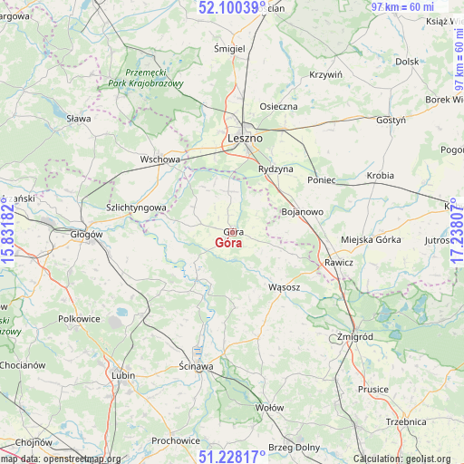
Góra GPS coordinates[2]
51° 39' 58.968" North, 16° 32' 5.784" East
| Map corner | latitude | longitude |
|---|---|---|
| Upper-left | 52.10039°, | 15.83182° |
| Center: | 51.66638°, | 16.53494° |
| Lower-right: | 51.22817°, | 17.23807° |
| Map W x H: | 97×97 km | = 60.3×60.3mi |
| max Lat: | 54.83135° ⇑40.4% North |
| Góra: | 51.66638° |
| min Lat: | ⇓59.6% South 49.21328° |
| min Long | Góra | max Long |
| 14.20249° | 16.53494° | 24.03723° |
| W 10.8%⇐ | ⇒89.2% E |
Elevation
Elevation of Góra is 90 m = 295 ft, and this is 101.4 m = 333 ft below average elevation for this country.
| Max E: |
974 m = 3196 ft | 84.6% |
| Avg. | 191.4 m = 628 ft | |
| Góra | 90 m = 295 ft | |
Min E: |
-3 m = -10 ft | 15.4% |
See also: Poland elevation on elevation.city.
Geographical zone
Góra is located in North temperate zone (between Tropic of Cancer and the Arctic Circle). Distance of this North polar circle is 1656.4 km =1029.2 mi to North.| Distance of | km | miles | from Góra |
|---|---|---|---|
| North Pole | 4262.3 | 2648.5 | to North |
| Arctic Circle | 1656.4 | 1029.2 | to North |
| Tropic Cancer | 3138.8 | 1950.4 | to South |
| Equator | 5744.8 | 3569.7 | to South |


Nearby cities:
15 places around Góra: (largest is in red/bold)
• Bojanowo
15.4 km =9.6 mi,  72°
72°
• Chróścina
8.6 km =5.3 mi,  2°
2°
• Golina Wielka
17.6 km =10.9 mi,  77°
77°
• Jemielno
15.8 km =9.8 mi,  177°
177°
• Leszno
19.5 km =12.1 mi,  8°
8°
• Niechlów
11.8 km =7.3 mi,  282°
282°
• Poniec
21.7 km =13.5 mi,  60°
60°
• Rawicz
23.2 km =14.4 mi,  105°
105°
• Rydzyna
16.2 km =10.1 mi,  34°
34°
• Szlichtyngowa
20.7 km =12.9 mi, 284°
• Wilkowice
24.3 km =15.1 mi,  359°
359°
• Wińsko
22.5 km =14 mi,  165°
165°
• Wschowa
21.7 km =13.5 mi,  316°
316°
• Wąsosz
15.8 km =9.8 mi,  137°
137°
• Święciechowa
21.1 km =13.1 mi,  353°
353°
Sources, notices
• [Note1] Compared only with cities in Poland existing in our database
• [Src1] Map data: © OpenStreetMap contributors (CC-BY-SA)
• [Src2] Other city data from geonames.org with taken over terms of usage.
• [Src3] Geographical zone / Annual Mean Temperature by Robert A. Rohde @ Wikipedia
