Jerzmanowa geodata
Jerzmanowa (Lower Silesia) is a populated place; located in Poland in Europe/Warsaw (GMT+2) time zone. With population of 600 people, there are 3270 cities with bigger population in this country. Compared to other cities in Poland, 57.8% of cities are located further ↓South; 92.3% of cities are located further →East and 60.6% of cities have lower elevation than Jerzmanowa. Note1


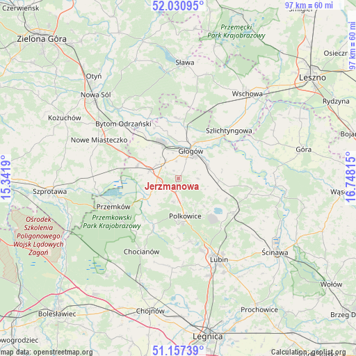
Jerzmanowa GPS coordinates[2]
51° 35' 46.572" North, 16° 2' 42.072" East
| Map corner | latitude | longitude |
|---|---|---|
| Upper-left | 52.03095°, | 15.3419° |
| Center: | 51.59627°, | 16.04502° |
| Lower-right: | 51.15739°, | 16.74815° |
| Map W x H: | 97.1×97.1 km | = 60.3×60.3mi |
| max Lat: | 54.83135° ⇑42.2% North |
| Jerzmanowa: | 51.59627° |
| min Lat: | ⇓57.8% South 49.21328° |
| min Long | Jerzmanowa | max Long |
| 14.20249° | 16.04502° | 24.03723° |
| W 7.7%⇐ | ⇒92.3% E |
Elevation
Elevation of Jerzmanowa is 202 m = 663 ft, and this is 10.6 m = 35 ft above average elevation for this country.
| Max E: |
974 m = 3196 ft | 39.4% |
| Jerzmanowa | 202 m 663 ft | |
| Avg. | 191.4 m = 628 ft | |
Min E: |
-3 m = -10 ft | 60.6% |
See also: Poland elevation on elevation.city.
Geographical zone
Jerzmanowa is located in North temperate zone (between Tropic of Cancer and the Arctic Circle). Distance of this North polar circle is 1664.2 km =1034.1 mi to North.| Distance of | km | miles | from Jerzmanowa |
|---|---|---|---|
| North Pole | 4270.1 | 2653.3 | to North |
| Arctic Circle | 1664.2 | 1034.1 | to North |
| Tropic Cancer | 3131 | 1945.5 | to South |
| Equator | 5737 | 3564.8 | to South |


Nearby cities:
15 places around Jerzmanowa: (largest is in red/bold)
• Bielawy
20.6 km =12.8 mi,  339°
339°
• Bytom Odrzański
21.4 km =13.3 mi,  314°
314°
• Chocianów
22.1 km =13.7 mi,  206°
206°
• Gaworzyce
11.8 km =7.3 mi,  287°
287°
• Grębocice
8.5 km =5.3 mi,  87°
87°
• Głogów
8 km =5 mi,  19°
19°
• Kotla
16.6 km =10.3 mi,  357°
357°
• Kłobuczyn
8.1 km =5 mi, 285°
• Niegosławice
22.9 km =14.2 mi,  267°
267°
• Polkowice
10.4 km =6.5 mi,  169°
169°
• Przemków
19 km =11.8 mi,  245°
245°
• Radwanice
7.3 km =4.5 mi, 247°
• Rudna
17.9 km =11.1 mi,  122°
122°
• Szlichtyngowa
18.8 km =11.7 mi,  46°
46°
• Żukowice
9.5 km =5.9 mi,  333°
333°
Sources, notices
• [Note1] Compared only with cities in Poland existing in our database
• [Src1] Map data: © OpenStreetMap contributors (CC-BY-SA)
• [Src2] Other city data from geonames.org with taken over terms of usage.
• [Src3] Geographical zone / Annual Mean Temperature by Robert A. Rohde @ Wikipedia
