Kotla geodata
Kotla (Lower Silesia) is a populated place; located in Poland in Europe/Warsaw (GMT+2) time zone. With population of 1,400 people, there are 1959 cities with bigger population in this country. Compared to other cities in Poland, 61% of cities are located further ↓South; 92.3% of cities are located further →East and 86.1% of cities have higher elevation than Kotla. Note1


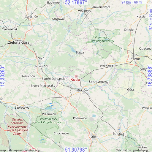
Kotla GPS coordinates[2]
51° 44' 43.512" North, 16° 2' 8.7" East
| Map corner | latitude | longitude |
|---|---|---|
| Upper-left | 52.17867°, | 15.33263° |
| Center: | 51.74542°, | 16.03575° |
| Lower-right: | 51.30798°, | 16.73888° |
| Map W x H: | 96.8×96.8 km | = 60.1×60.1mi |
| max Lat: | 54.83135° ⇑39% North |
| Kotla: | 51.74542° |
| min Lat: | ⇓61% South 49.21328° |
| min Long | Kotla | max Long |
| 14.20249° | 16.03575° | 24.03723° |
| W 7.7%⇐ | ⇒92.3% E |
Elevation
Elevation of Kotla is 87 m = 285 ft, and this is 104.4 m = 343 ft below average elevation for this country.
| Max E: |
974 m = 3196 ft | 86.1% |
| Avg. | 191.4 m = 628 ft | |
| Kotla | 87 m = 285 ft | |
Min E: |
-3 m = -10 ft | 13.9% |
See also: Poland elevation on elevation.city.
Geographical zone
Kotla is located in North temperate zone (between Tropic of Cancer and the Arctic Circle). Distance of this North polar circle is 1647.6 km =1023.8 mi to North.| Distance of | km | miles | from Kotla |
|---|---|---|---|
| North Pole | 4253.5 | 2643 | to North |
| Arctic Circle | 1647.6 | 1023.8 | to North |
| Tropic Cancer | 3147.6 | 1955.8 | to South |
| Equator | 5753.6 | 3575.1 | to South |


Nearby cities:
15 places around Kotla: (largest is in red/bold)
• Bielawy
7.2 km =4.5 mi,  291°
291°
• Bytom Odrzański
14.7 km =9.1 mi,  263°
263°
• Gaworzyce
16.8 km =10.4 mi,  219°
219°
• Grębocice
18.6 km =11.6 mi,  150°
150°
• Głogów
9.7 km =6 mi,  159°
159°
• Jerzmanowa
16.6 km =10.3 mi,  177°
177°
• Kłobuczyn
16.1 km =10 mi,  206°
206°
• Lubięcin
19.5 km =12.1 mi,  325°
325°
• Przyborów
19.3 km =12 mi, 288°
• Radwanice
20.3 km =12.6 mi,  197°
197°
• Siedlisko
15.5 km =9.6 mi,  279°
279°
• Szlichtyngowa
14.8 km =9.2 mi,  104°
104°
• Sława
14.8 km =9.2 mi,  9°
9°
• Wschowa
20.5 km =12.7 mi,  70°
70°
• Żukowice
8.8 km =5.5 mi, 204°
Sources, notices
• [Note1] Compared only with cities in Poland existing in our database
• [Src1] Map data: © OpenStreetMap contributors (CC-BY-SA)
• [Src2] Other city data from geonames.org with taken over terms of usage.
• [Src3] Geographical zone / Annual Mean Temperature by Robert A. Rohde @ Wikipedia
