Wijewo geodata
Wijewo (Greater Poland) is a seat of a third-order administrative division; located in Poland in Europe/Warsaw (GMT+2) time zone. With population of 1,200 people, there are 2164 cities with bigger population in this country. Compared to other cities in Poland, 64% of cities are located further ↓South; 91.5% of cities are located further →East and 92.4% of cities have higher elevation than Wijewo. Note1


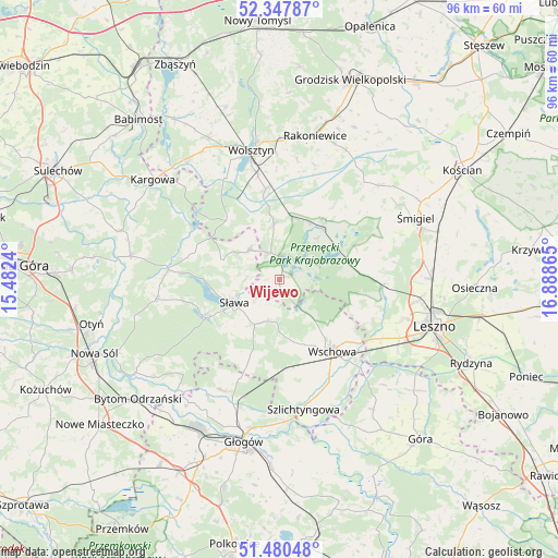
Wijewo GPS coordinates[2]
51° 54' 58.572" North, 16° 11' 7.872" East
| Map corner | latitude | longitude |
|---|---|---|
| Upper-left | 52.34787°, | 15.4824° |
| Center: | 51.91627°, | 16.18552° |
| Lower-right: | 51.48048°, | 16.88865° |
| Map W x H: | 96.4×96.4 km | = 59.9×59.9mi |
| max Lat: | 54.83135° ⇑36% North |
| Wijewo: | 51.91627° |
| min Lat: | ⇓64% South 49.21328° |
| min Long | Wijewo | max Long |
| 14.20249° | 16.18552° | 24.03723° |
| W 8.5%⇐ | ⇒91.5% E |
Elevation
Elevation of Wijewo is 63 m = 207 ft, and this is 128.4 m = 421 ft below average elevation for this country.
| Max E: |
974 m = 3196 ft | 92.4% |
| Avg. | 191.4 m = 628 ft | |
| Wijewo | 63 m = 207 ft | |
Min E: |
-3 m = -10 ft | 7.6% |
See also: Poland elevation on elevation.city.
Geographical zone
Wijewo is located in North temperate zone (between Tropic of Cancer and the Arctic Circle). Distance of this North polar circle is 1628.6 km =1012 mi to North.| Distance of | km | miles | from Wijewo |
|---|---|---|---|
| North Pole | 4234.5 | 2631.2 | to North |
| Arctic Circle | 1628.6 | 1012 | to North |
| Tropic Cancer | 3166.6 | 1967.6 | to South |
| Equator | 5772.5 | 3586.9 | to South |


Nearby cities:
15 places around Wijewo: (largest is in red/bold)
• Bielawy
23.6 km =14.7 mi,  226°
226°
• Brenno
2.1 km =1.3 mi,  70°
70°
• Kolsko
16.3 km =10.1 mi,  287°
287°
• Konotop
19.4 km =12.1 mi,  275°
275°
• Kotla
21.6 km =13.4 mi,  208°
208°
• Lubięcin
21.4 km =13.3 mi,  262°
262°
• Przemęt
12.9 km =8 mi,  37°
37°
• Szlichtyngowa
23 km =14.3 mi,  169°
169°
• Sława
9 km =5.6 mi,  240°
240°
• Wielichowo
24.9 km =15.5 mi,  27°
27°
• Wilkowice
24.2 km =15 mi,  98°
98°
• Wolsztyn
22.6 km =14 mi,  348°
348°
• Wschowa
15.1 km =9.4 mi,  143°
143°
• Włoszakowice
12.3 km =7.6 mi,  84°
84°
• Święciechowa
22.5 km =14 mi,  107°
107°
Sources, notices
• [Note1] Compared only with cities in Poland existing in our database
• [Src1] Map data: © OpenStreetMap contributors (CC-BY-SA)
• [Src2] Other city data from geonames.org with taken over terms of usage.
• [Src3] Geographical zone / Annual Mean Temperature by Robert A. Rohde @ Wikipedia
