Sława geodata
Sława (Lubusz) is a seat of a third-order administrative division; located in Poland in Europe/Warsaw (GMT+2) time zone. With population of 4,038 people, there are 808 cities with bigger population in this country. Compared to other cities in Poland, 63.2% of cities are located further ↓South; 92.2% of cities are located further →East and 93.1% of cities have higher elevation than Sława. Note1


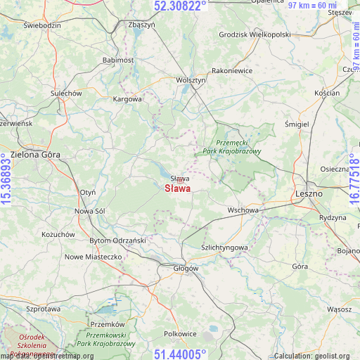
Sława GPS coordinates[2]
51° 52' 34.428" North, 16° 4' 19.38" East
| Map corner | latitude | longitude |
|---|---|---|
| Upper-left | 52.30822°, | 15.36893° |
| Center: | 51.87623°, | 16.07205° |
| Lower-right: | 51.44005°, | 16.77518° |
| Map W x H: | 96.5×96.5 km | = 60×60mi |
| max Lat: | 54.83135° ⇑36.8% North |
| Sława: | 51.87623° |
| min Lat: | ⇓63.2% South 49.21328° |
| min Long | Sława | max Long |
| 14.20249° | 16.07205° | 24.03723° |
| W 7.8%⇐ | ⇒92.2% E |
Elevation
Elevation of Sława is 59 m = 194 ft, and this is 132.4 m = 434 ft below average elevation for this country.
| Max E: |
974 m = 3196 ft | 93.1% |
| Avg. | 191.4 m = 628 ft | |
| Sława | 59 m = 194 ft | |
Min E: |
-3 m = -10 ft | 6.9% |
See also: Poland elevation on elevation.city.
Geographical zone
Sława is located in North temperate zone (between Tropic of Cancer and the Arctic Circle). Distance of this North polar circle is 1633.1 km =1014.8 mi to North.| Distance of | km | miles | from Sława |
|---|---|---|---|
| North Pole | 4239 | 2634 | to North |
| Arctic Circle | 1633.1 | 1014.8 | to North |
| Tropic Cancer | 3162.2 | 1964.9 | to South |
| Equator | 5768.1 | 3584.1 | to South |


Nearby cities:
15 places around Sława: (largest is in red/bold)
• Bielawy
15.1 km =9.4 mi,  217°
217°
• Bojadła
19.9 km =12.4 mi,  295°
295°
• Brenno
11.1 km =6.9 mi,  62°
62°
• Kolsko
12.2 km =7.6 mi,  320°
320°
• Konotop
13.1 km =8.1 mi, 298°
• Kotla
14.8 km =9.2 mi,  189°
189°
• Lubięcin
13.5 km =8.4 mi,  276°
276°
• Przemęt
21.5 km =13.4 mi,  46°
46°
• Przyborów
22.5 km =14 mi,  247°
247°
• Siedlisko
21.4 km =13.3 mi,  236°
236°
• Szlichtyngowa
21.7 km =13.5 mi,  146°
146°
• Wijewo
9 km =5.6 mi, 60°
• Wschowa
18.5 km =11.5 mi,  114°
114°
• Włoszakowice
20.9 km =13 mi,  74°
74°
• Żukowice
23.4 km =14.5 mi,  195°
195°
Sources, notices
• [Note1] Compared only with cities in Poland existing in our database
• [Src1] Map data: © OpenStreetMap contributors (CC-BY-SA)
• [Src2] Other city data from geonames.org with taken over terms of usage.
• [Src3] Geographical zone / Annual Mean Temperature by Robert A. Rohde @ Wikipedia
