Bielawy geodata
Bielawy (Lubusz) is a populated place; located in Poland in Europe/Warsaw (GMT+2) time zone. With population of 750 people, there are 2953 cities with bigger population in this country. Compared to other cities in Poland, 61.4% of cities are located further ↓South; 92.8% of cities are located further →East and 91.1% of cities have higher elevation than Bielawy. Note1


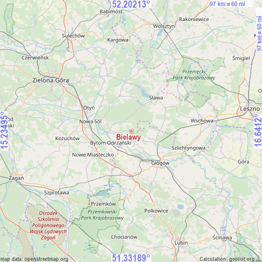
Bielawy GPS coordinates[2]
51° 46' 8.796" North, 15° 56' 17.052" East
| Map corner | latitude | longitude |
|---|---|---|
| Upper-left | 52.20213°, | 15.23495° |
| Center: | 51.76911°, | 15.93807° |
| Lower-right: | 51.33189°, | 16.6412° |
| Map W x H: | 96.8×96.8 km | = 60.1×60.1mi |
| max Lat: | 54.83135° ⇑38.6% North |
| Bielawy: | 51.76911° |
| min Lat: | ⇓61.4% South 49.21328° |
| min Long | Bielawy | max Long |
| 14.20249° | 15.93807° | 24.03723° |
| W 7.2%⇐ | ⇒92.8% E |
Elevation
Elevation of Bielawy is 70 m = 230 ft, and this is 121.4 m = 398 ft below average elevation for this country.
| Max E: |
974 m = 3196 ft | 91.1% |
| Avg. | 191.4 m = 628 ft | |
| Bielawy | 70 m = 230 ft | |
Min E: |
-3 m = -10 ft | 8.9% |
See also: Poland elevation on elevation.city.
Geographical zone
Bielawy is located in North temperate zone (between Tropic of Cancer and the Arctic Circle). Distance of this North polar circle is 1645 km =1022.2 mi to North.| Distance of | km | miles | from Bielawy |
|---|---|---|---|
| North Pole | 4250.9 | 2641.4 | to North |
| Arctic Circle | 1645 | 1022.2 | to North |
| Tropic Cancer | 3150.3 | 1957.5 | to South |
| Equator | 5756.2 | 3576.7 | to South |


Nearby cities:
15 places around Bielawy: (largest is in red/bold)
• Bobrowniki
17.7 km =11 mi,  306°
306°
• Bytom Odrzański
9 km =5.6 mi,  241°
241°
• Gaworzyce
16.2 km =10.1 mi,  193°
193°
• Głogów
15.5 km =9.6 mi,  139°
139°
• Konotop
18.2 km =11.3 mi,  352°
352°
• Kotla
7.2 km =4.5 mi,  111°
111°
• Kłobuczyn
17.1 km =10.6 mi,  181°
181°
• Lubięcin
14.1 km =8.8 mi,  342°
342°
• Nowa Sól
15.7 km =9.8 mi,  284°
284°
• Nowe Miasteczko
16.7 km =10.4 mi, 238°
• Otyń
17.9 km =11.1 mi,  299°
299°
• Przyborów
12.1 km =7.5 mi,  286°
286°
• Siedlisko
8.5 km =5.3 mi,  269°
269°
• Sława
15.1 km =9.4 mi,  37°
37°
• Żukowice
11.2 km =7 mi,  163°
163°
Sources, notices
• [Note1] Compared only with cities in Poland existing in our database
• [Src1] Map data: © OpenStreetMap contributors (CC-BY-SA)
• [Src2] Other city data from geonames.org with taken over terms of usage.
• [Src3] Geographical zone / Annual Mean Temperature by Robert A. Rohde @ Wikipedia
