Świdwin geodata
Świdwin (West Pomerania) is a populated place; located in Poland in Europe/Warsaw (GMT+2) time zone. With population of 16,076 people, there are 310 cities with bigger population in this country. Compared to other cities in Poland, 92.1% of cities are located further ↓South; 93.8% of cities are located further →East and 83.7% of cities have higher elevation than Świdwin. Note1


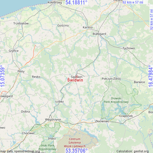
Świdwin GPS coordinates[2]
53° 46' 28.704" North, 15° 46' 36.156" East
| Map corner | latitude | longitude |
|---|---|---|
| Upper-left | 54.18811°, | 15.07359° |
| Center: | 53.77464°, | 15.77671° |
| Lower-right: | 53.35706°, | 16.47984° |
| Map W x H: | 92.4×92.4 km | = 57.4×57.4mi |
| max Lat: | 54.83135° ⇑7.9% North |
| Świdwin: | 53.77464° |
| min Lat: | ⇓92.1% South 49.21328° |
| min Long | Świdwin | max Long |
| 14.20249° | 15.77671° | 24.03723° |
| W 6.2%⇐ | ⇒93.8% E |
Elevation
Elevation of Świdwin is 92 m = 302 ft, and this is 99.4 m = 326 ft below average elevation for this country.
| Max E: |
974 m = 3196 ft | 83.7% |
| Avg. | 191.4 m = 628 ft | |
| Świdwin | 92 m = 302 ft | |
Min E: |
-3 m = -10 ft | 16.3% |
See also: Poland elevation on elevation.city.
Geographical zone
Świdwin is located in North temperate zone (between Tropic of Cancer and the Arctic Circle). Distance of this North polar circle is 1422 km =883.6 mi to North.| Distance of | km | miles | from Świdwin |
|---|---|---|---|
| North Pole | 4027.9 | 2502.8 | to North |
| Arctic Circle | 1422 | 883.6 | to North |
| Tropic Cancer | 3373.3 | 2096.1 | to South |
| Equator | 5979.2 | 3715.3 | to South |


Nearby cities:
15 places around Świdwin: (largest is in red/bold)
• Białogard
29.3 km =18.2 mi,  28°
28°
• Brzeżno
8.4 km =5.2 mi,  173°
173°
• Drawsko Pomorskie
27.2 km =16.9 mi,  175°
175°
• Gościno
31.8 km =19.8 mi,  345°
345°
• Karlino
29.7 km =18.5 mi,  12°
12°
• Mysłowice
16.2 km =10.1 mi,  324°
324°
• Połczyn-Zdrój
21 km =13 mi,  93°
93°
• Radowo Małe
24.8 km =15.4 mi,  240°
240°
• Resko
24.4 km =15.2 mi,  269°
269°
• Rymań
24.9 km =15.5 mi, 319°
• Rąbino
15 km =9.3 mi,  47°
47°
• Sławoborze
13.6 km =8.5 mi,  340°
340°
• Węgorzyno
29.7 km =18.5 mi,  208°
208°
• Złocieniec
31 km =19.3 mi,  150°
150°
• Łobez
18.2 km =11.3 mi, 214°
Sources, notices
• [Note1] Compared only with cities in Poland existing in our database
• [Src1] Map data: © OpenStreetMap contributors (CC-BY-SA)
• [Src2] Other city data from geonames.org with taken over terms of usage.
• [Src3] Geographical zone / Annual Mean Temperature by Robert A. Rohde @ Wikipedia
