Złocieniec geodata
Złocieniec (West Pomerania) is a seat of a third-order administrative division; located in Poland in Europe/Warsaw (GMT+2) time zone. With population of 13,337 people, there are 367 cities with bigger population in this country. Compared to other cities in Poland, 89.9% of cities are located further ↓South; 92.4% of cities are located further →East and 67.4% of cities have higher elevation than Złocieniec. Note1


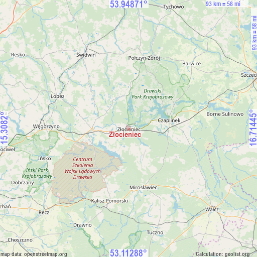
Złocieniec GPS coordinates[2]
53° 31' 58.296" North, 16° 0' 40.752" East
| Map corner | latitude | longitude |
|---|---|---|
| Upper-left | 53.94871°, | 15.3082° |
| Center: | 53.53286°, | 16.01132° |
| Lower-right: | 53.11288°, | 16.71445° |
| Map W x H: | 92.9×92.9 km | = 57.7×57.7mi |
| max Lat: | 54.83135° ⇑10.1% North |
| Złocieniec: | 53.53286° |
| min Lat: | ⇓89.9% South 49.21328° |
| min Long | Złocieniec | max Long |
| 14.20249° | 16.01132° | 24.03723° |
| W 7.6%⇐ | ⇒92.4% E |
Elevation
Elevation of Złocieniec is 127 m = 417 ft, and this is 64.4 m = 211 ft below average elevation for this country.
| Max E: |
974 m = 3196 ft | 67.4% |
| Avg. | 191.4 m = 628 ft | |
| Złocieniec | 127 m = 417 ft | |
Min E: |
-3 m = -10 ft | 32.6% |
See also: Poland elevation on elevation.city.
Geographical zone
Złocieniec is located in North temperate zone (between Tropic of Cancer and the Arctic Circle). Distance of this North polar circle is 1448.9 km =900.3 mi to North.| Distance of | km | miles | from Złocieniec |
|---|---|---|---|
| North Pole | 4054.8 | 2519.5 | to North |
| Arctic Circle | 1448.9 | 900.3 | to North |
| Tropic Cancer | 3346.4 | 2079.4 | to South |
| Equator | 5952.3 | 3698.6 | to South |


Nearby cities:
15 places around Złocieniec: (largest is in red/bold)
• Barwice
32.7 km =20.3 mi,  43°
43°
• Borne Sulinowo
34.9 km =21.7 mi,  81°
81°
• Brzeżno
23.5 km =14.6 mi,  321°
321°
• Czaplinek
14.9 km =9.3 mi, 79°
• Drawsko Pomorskie
13.3 km =8.3 mi,  268°
268°
• Ińsko
32.3 km =20.1 mi,  250°
250°
• Kalisz Pomorski
26.9 km =16.7 mi,  194°
194°
• Mirosławiec
22 km =13.7 mi,  166°
166°
• Połczyn-Zdrój
26.3 km =16.3 mi,  12°
12°
• Rąbino
37.3 km =23.2 mi,  353°
353°
• Wierzchowo
10 km =6.2 mi,  144°
144°
• Węgorzyno
29.9 km =18.6 mi, 271°
• Łobez
28.3 km =17.6 mi,  294°
294°
• Łubowo
25.8 km =16 mi, 76°
• Świdwin
31 km =19.3 mi,  330°
330°
Sources, notices
• [Note1] Compared only with cities in Poland existing in our database
• [Src1] Map data: © OpenStreetMap contributors (CC-BY-SA)
• [Src2] Other city data from geonames.org with taken over terms of usage.
• [Src3] Geographical zone / Annual Mean Temperature by Robert A. Rohde @ Wikipedia
