Węgorzyno geodata
Węgorzyno (West Pomerania) is a populated place; located in Poland in Europe/Warsaw (GMT+2) time zone. With population of 3,009 people, there are 1039 cities with bigger population in this country. Compared to other cities in Poland, 90.1% of cities are located further ↓South; 95% of cities are located further →East and 82.7% of cities have higher elevation than Węgorzyno. Note1


Węgorzyno GPS coordinates[2]
53° 32' 27.636" North, 15° 33' 34.704" East
| Map corner | latitude | longitude |
|---|---|---|
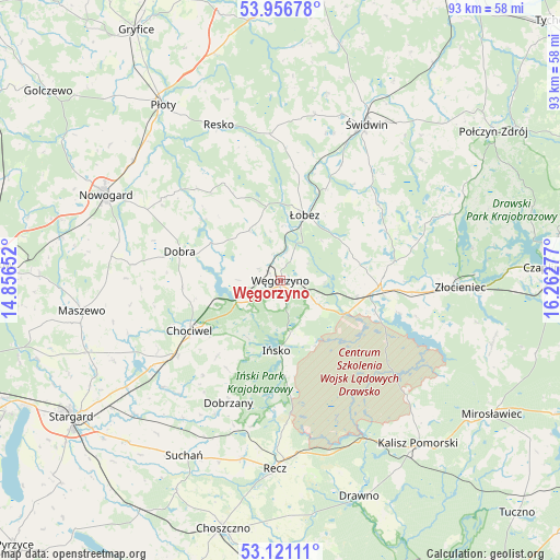
| Upper-left | 53.95678°, | 14.85652° |
| Center: | 53.54101°, | 15.55964° |
| Lower-right: | 53.12111°, | 16.26277° |
| Map W x H: | 92.9×92.9 km | = 57.7×57.7mi |
| max Lat: | 54.83135° ⇑9.9% North |
| Węgorzyno: | 53.54101° |
| min Lat: | ⇓90.1% South 49.21328° |
| min Long | Węgorzyno | max Long |
| 14.20249° | 15.55964° | 24.03723° |
| W 5%⇐ | ⇒95% E |
Elevation
Elevation of Węgorzyno is 94 m = 308 ft, and this is 97.4 m = 320 ft below average elevation for this country.
| Max E: |
974 m = 3196 ft | 82.7% |
| Avg. | 191.4 m = 628 ft | |
| Węgorzyno | 94 m = 308 ft | |
Min E: |
-3 m = -10 ft | 17.3% |
See also: Poland elevation on elevation.city.
Geographical zone
Węgorzyno is located in North temperate zone (between Tropic of Cancer and the Arctic Circle). Distance of this North polar circle is 1448 km =899.7 mi to North.| Distance of | km | miles | from Węgorzyno |
|---|---|---|---|
| North Pole | 4053.9 | 2519 | to North |
| Arctic Circle | 1448 | 899.7 | to North |
| Tropic Cancer | 3347.3 | 2079.9 | to South |
| Equator | 5953.2 | 3699.1 | to South |


Nearby cities:
15 places around Węgorzyno: (largest is in red/bold)
• Brzeżno
23.3 km =14.5 mi,  41°
41°
• Chociwel
17.1 km =10.6 mi,  241°
241°
• Dobra
17.3 km =10.7 mi,  286°
286°
• Dobrzany
22 km =13.7 mi,  203°
203°
• Drawsko Pomorskie
16.6 km =10.3 mi,  94°
94°
• Ińsko
11.7 km =7.3 mi,  183°
183°
• Marianowo
26.2 km =16.3 mi,  227°
227°
• Nowogard
32.8 km =20.4 mi,  296°
296°
• Radowo Małe
15.7 km =9.8 mi,  332°
332°
• Recz
31.3 km =19.4 mi, 181°
• Resko
27.7 km =17.2 mi,  338°
338°
• Stara Dąbrowa
30.5 km =19 mi, 244°
• Złocieniec
29.9 km =18.6 mi, 91°
• Łobez
11.6 km =7.2 mi,  20°
20°
• Świdwin
29.7 km =18.5 mi,  28°
28°
Sources, notices
• [Note1] Compared only with cities in Poland existing in our database
• [Src1] Map data: © OpenStreetMap contributors (CC-BY-SA)
• [Src2] Other city data from geonames.org with taken over terms of usage.
• [Src3] Geographical zone / Annual Mean Temperature by Robert A. Rohde @ Wikipedia
