Radowo Małe geodata
Radowo Małe (West Pomerania) is a populated place; located in Poland in Europe/Warsaw (GMT+2) time zone. With population of 1,200 people, there are 2164 cities with bigger population in this country. Compared to other cities in Poland, 91.2% of cities are located further ↓South; 95.6% of cities are located further →East and 83.7% of cities have higher elevation than Radowo Małe. Note1


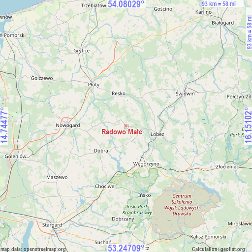
Radowo Małe GPS coordinates[2]
53° 39' 56.7" North, 15° 26' 52.404" East
| Map corner | latitude | longitude |
|---|---|---|
| Upper-left | 54.08029°, | 14.74477° |
| Center: | 53.66575°, | 15.44789° |
| Lower-right: | 53.24709°, | 16.15102° |
| Map W x H: | 92.6×92.6 km | = 57.5×57.5mi |
| max Lat: | 54.83135° ⇑8.8% North |
| Radowo Małe: | 53.66575° |
| min Lat: | ⇓91.2% South 49.21328° |
| min Long | Radowo Małe | max Long |
| 14.20249° | 15.44789° | 24.03723° |
| W 4.4%⇐ | ⇒95.6% E |
Elevation
Elevation of Radowo Małe is 92 m = 302 ft, and this is 99.4 m = 326 ft below average elevation for this country.
| Max E: |
974 m = 3196 ft | 83.7% |
| Avg. | 191.4 m = 628 ft | |
| Radowo Małe | 92 m = 302 ft | |
Min E: |
-3 m = -10 ft | 16.3% |
See also: Poland elevation on elevation.city.
Geographical zone
Radowo Małe is located in North temperate zone (between Tropic of Cancer and the Arctic Circle). Distance of this North polar circle is 1434.1 km =891.1 mi to North.| Distance of | km | miles | from Radowo Małe |
|---|---|---|---|
| North Pole | 4040 | 2510.3 | to North |
| Arctic Circle | 1434.1 | 891.1 | to North |
| Tropic Cancer | 3361.2 | 2088.6 | to South |
| Equator | 5967.1 | 3707.8 | to South |


Nearby cities:
15 places around Radowo Małe: (largest is in red/bold)
• Brzeżno
23 km =14.3 mi,  80°
80°
• Chociwel
23.4 km =14.5 mi,  198°
198°
• Dobra
12.7 km =7.9 mi,  225°
225°
• Drawsko Pomorskie
28.2 km =17.5 mi,  122°
122°
• Ińsko
26.4 km =16.4 mi,  165°
165°
• Mysłowice
28.2 km =17.5 mi,  25°
25°
• Nowogard
21.9 km =13.6 mi,  272°
272°
• Osina
29.5 km =18.3 mi,  256°
256°
• Płoty
19.3 km =12 mi,  321°
321°
• Resko
12.2 km =7.6 mi,  347°
347°
• Rymań
31.4 km =19.5 mi,  9°
9°
• Sławoborze
30.2 km =18.8 mi, 34°
• Węgorzyno
15.7 km =9.8 mi,  152°
152°
• Łobez
11.8 km =7.3 mi,  104°
104°
• Świdwin
24.8 km =15.4 mi,  60°
60°
Sources, notices
• [Note1] Compared only with cities in Poland existing in our database
• [Src1] Map data: © OpenStreetMap contributors (CC-BY-SA)
• [Src2] Other city data from geonames.org with taken over terms of usage.
• [Src3] Geographical zone / Annual Mean Temperature by Robert A. Rohde @ Wikipedia
