Połczyn-Zdrój geodata
Połczyn-Zdrój (West Pomerania) is a populated place; located in Poland in Europe/Warsaw (GMT+2) time zone. With population of 8,682 people, there are 490 cities with bigger population in this country. Compared to other cities in Poland, 92% of cities are located further ↓South; 92% of cities are located further →East and 83.7% of cities have higher elevation than Połczyn-Zdrój. Note1
Administrative division(s):
- Level 1: West Pomerania
- Level 2: Powiat świdwiński
- Level 3: Połczyn-Zdrój


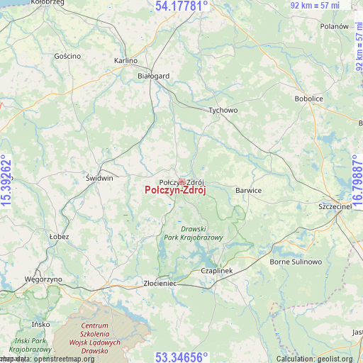
Połczyn-Zdrój GPS coordinates[2]
53° 45' 51.264" North, 16° 5' 44.664" East
| Map corner | latitude | longitude |
|---|---|---|
| Upper-left | 54.17781°, | 15.39262° |
| Center: | 53.76424°, | 16.09574° |
| Lower-right: | 53.34656°, | 16.79887° |
| Map W x H: | 92.4×92.4 km | = 57.4×57.4mi |
| max Lat: | 54.83135° ⇑8% North |
| Połczyn-Zdrój: | 53.76424° |
| min Lat: | ⇓92% South 49.21328° |
| min Long | Połczyn-Zdrój | max Long |
| 14.20249° | 16.09574° | 24.03723° |
| W 8%⇐ | ⇒92% E |
Elevation
Elevation of Połczyn-Zdrój is 92 m = 302 ft, and this is 99.4 m = 326 ft below average elevation for this country.
| Max E: |
974 m = 3196 ft | 83.7% |
| Avg. | 191.4 m = 628 ft | |
| Połczyn-Zdrój | 92 m = 302 ft | |
Min E: |
-3 m = -10 ft | 16.3% |
See also: Poland elevation on elevation.city.
Geographical zone
Połczyn-Zdrój is located in North temperate zone (between Tropic of Cancer and the Arctic Circle). Distance of this North polar circle is 1423.2 km =884.3 mi to North.| Distance of | km | miles | from Połczyn-Zdrój |
|---|---|---|---|
| North Pole | 4029 | 2503.5 | to North |
| Arctic Circle | 1423.2 | 884.3 | to North |
| Tropic Cancer | 3372.1 | 2095.3 | to South |
| Equator | 5978 | 3714.6 | to South |


Nearby cities:
15 places around Połczyn-Zdrój: (largest is in red/bold)
• Barwice
17.2 km =10.7 mi,  97°
97°
• Białogard
27.9 km =17.3 mi,  345°
345°
• Brzeżno
21.2 km =13.2 mi,  250°
250°
• Czaplinek
24.7 km =15.3 mi,  158°
158°
• Drawsko Pomorskie
32.1 km =19.9 mi,  215°
215°
• Grzmiąca
23.7 km =14.7 mi,  69°
69°
• Karlino
33.3 km =20.7 mi,  334°
334°
• Mysłowice
33.6 km =20.9 mi,  295°
295°
• Rąbino
15.1 km =9.4 mi,  318°
318°
• Sławoborze
29.1 km =18.1 mi, 298°
• Tychowo
21.1 km =13.1 mi,  30°
30°
• Wierzchowo
33.8 km =21 mi,  179°
179°
• Złocieniec
26.3 km =16.3 mi,  192°
192°
• Łubowo
27.8 km =17.3 mi,  135°
135°
• Świdwin
21 km =13 mi,  273°
273°
Sources, notices
• [Note1] Compared only with cities in Poland existing in our database
• [Src1] Map data: © OpenStreetMap contributors (CC-BY-SA)
• [Src2] Other city data from geonames.org with taken over terms of usage.
• [Src3] Geographical zone / Annual Mean Temperature by Robert A. Rohde @ Wikipedia
