Rąbino geodata
Rąbino (West Pomerania) is a populated place; located in Poland in Europe/Warsaw (GMT+2) time zone. With population of 1,100 people, there are 2307 cities with bigger population in this country. Compared to other cities in Poland, 92.9% of cities are located further ↓South; 92.7% of cities are located further →East and 76.4% of cities have higher elevation than Rąbino. Note1


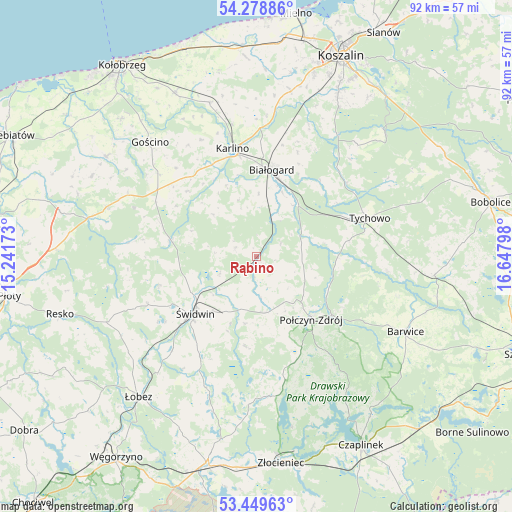
Rąbino GPS coordinates[2]
53° 51' 58.68" North, 15° 56' 41.46" East
| Map corner | latitude | longitude |
|---|---|---|
| Upper-left | 54.27886°, | 15.24173° |
| Center: | 53.8663°, | 15.94485° |
| Lower-right: | 53.44963°, | 16.64798° |
| Map W x H: | 92.2×92.2 km | = 57.3×57.3mi |
| max Lat: | 54.83135° ⇑7.1% North |
| Rąbino: | 53.8663° |
| min Lat: | ⇓92.9% South 49.21328° |
| min Long | Rąbino | max Long |
| 14.20249° | 15.94485° | 24.03723° |
| W 7.3%⇐ | ⇒92.7% E |
Elevation
Elevation of Rąbino is 107 m = 351 ft, and this is 84.4 m = 277 ft below average elevation for this country.
| Max E: |
974 m = 3196 ft | 76.4% |
| Avg. | 191.4 m = 628 ft | |
| Rąbino | 107 m = 351 ft | |
Min E: |
-3 m = -10 ft | 23.6% |
See also: Poland elevation on elevation.city.
Geographical zone
Rąbino is located in North temperate zone (between Tropic of Cancer and the Arctic Circle). Distance of this North polar circle is 1411.8 km =877.3 mi to North.| Distance of | km | miles | from Rąbino |
|---|---|---|---|
| North Pole | 4017.7 | 2496.5 | to North |
| Arctic Circle | 1411.8 | 877.3 | to North |
| Tropic Cancer | 3383.5 | 2102.4 | to South |
| Equator | 5989.4 | 3721.6 | to South |


Nearby cities:
15 places around Rąbino: (largest is in red/bold)
• Barwice
30.1 km =18.7 mi,  116°
116°
• Białogard
15.9 km =9.9 mi,  10°
10°
• Biesiekierz
30.3 km =18.8 mi, 11°
• Brzeżno
21.1 km =13.1 mi,  208°
208°
• Dygowo
32.8 km =20.4 mi,  333°
333°
• Gościno
28.1 km =17.5 mi,  317°
317°
• Grzmiąca
32.3 km =20.1 mi,  95°
95°
• Karlino
19.3 km =12 mi,  346°
346°
• Mysłowice
20.6 km =12.8 mi,  278°
278°
• Połczyn-Zdrój
15.1 km =9.4 mi,  138°
138°
• Rymań
28.6 km =17.8 mi,  287°
287°
• Siemyśl
32.3 km =20.1 mi,  303°
303°
• Sławoborze
15.8 km =9.8 mi, 279°
• Tychowo
21.6 km =13.4 mi,  71°
71°
• Świdwin
15 km =9.3 mi,  227°
227°
Sources, notices
• [Note1] Compared only with cities in Poland existing in our database
• [Src1] Map data: © OpenStreetMap contributors (CC-BY-SA)
• [Src2] Other city data from geonames.org with taken over terms of usage.
• [Src3] Geographical zone / Annual Mean Temperature by Robert A. Rohde @ Wikipedia
