Krzęcin geodata
Krzęcin (West Pomerania) is a seat of a third-order administrative division; located in Poland in Europe/Warsaw (GMT+2) time zone. With population of 747 people, there are 2976 cities with bigger population in this country. Compared to other cities in Poland, 84.6% of cities are located further ↓South; 95.4% of cities are located further →East and 90.6% of cities have higher elevation than Krzęcin. Note1


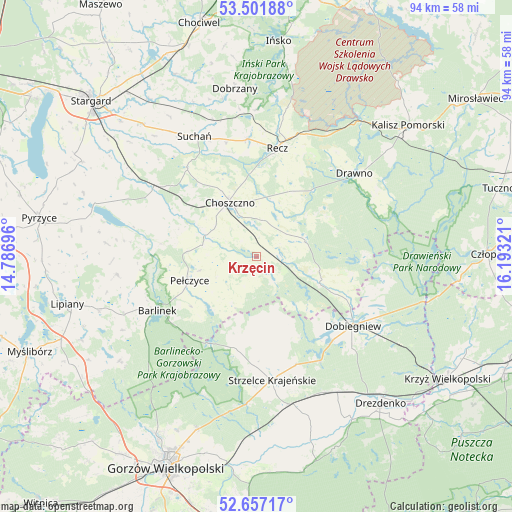
Krzęcin GPS coordinates[2]
53° 4' 53.76" North, 15° 29' 24.288" East
| Map corner | latitude | longitude |
|---|---|---|
| Upper-left | 53.50188°, | 14.78696° |
| Center: | 53.0816°, | 15.49008° |
| Lower-right: | 52.65717°, | 16.19321° |
| Map W x H: | 93.9×93.9 km | = 58.3×58.3mi |
| max Lat: | 54.83135° ⇑15.4% North |
| Krzęcin: | 53.0816° |
| min Lat: | ⇓84.6% South 49.21328° |
| min Long | Krzęcin | max Long |
| 14.20249° | 15.49008° | 24.03723° |
| W 4.6%⇐ | ⇒95.4% E |
Elevation
Elevation of Krzęcin is 72 m = 236 ft, and this is 119.4 m = 392 ft below average elevation for this country.
| Max E: |
974 m = 3196 ft | 90.6% |
| Avg. | 191.4 m = 628 ft | |
| Krzęcin | 72 m = 236 ft | |
Min E: |
-3 m = -10 ft | 9.4% |
See also: Poland elevation on elevation.city.
Geographical zone
Krzęcin is located in North temperate zone (between Tropic of Cancer and the Arctic Circle). Distance of this North polar circle is 1499.1 km =931.5 mi to North.| Distance of | km | miles | from Krzęcin |
|---|---|---|---|
| North Pole | 4104.9 | 2550.7 | to North |
| Arctic Circle | 1499.1 | 931.5 | to North |
| Tropic Cancer | 3296.2 | 2048.2 | to South |
| Equator | 5902.1 | 3667.4 | to South |


Nearby cities:
15 places around Krzęcin: (largest is in red/bold)
• Barlinek
20.6 km =12.8 mi,  241°
241°
• Bierzwnik
12.8 km =8 mi,  113°
113°
• Choszczno
10.8 km =6.7 mi,  334°
334°
• Dobiegniew
21.6 km =13.4 mi,  125°
125°
• Dobrzany
31.1 km =19.3 mi,  352°
352°
• Dolice
22.7 km =14.1 mi,  302°
302°
• Drawno
23.6 km =14.7 mi,  49°
49°
• Mostkowo
30.6 km =19 mi,  251°
251°
• Pełczyce
13.1 km =8.1 mi, 251°
• Przelewice
27.7 km =17.2 mi,  275°
275°
• Recz
20.2 km =12.6 mi,  10°
10°
• Stare Kurowo
28 km =17.4 mi,  153°
153°
• Strzelce Krajeńskie
22.9 km =14.2 mi,  173°
173°
• Suchań
24.6 km =15.3 mi, 333°
• Zwierzyń
28.2 km =17.5 mi, 169°
Sources, notices
• [Note1] Compared only with cities in Poland existing in our database
• [Src1] Map data: © OpenStreetMap contributors (CC-BY-SA)
• [Src2] Other city data from geonames.org with taken over terms of usage.
• [Src3] Geographical zone / Annual Mean Temperature by Robert A. Rohde @ Wikipedia
