Bierzwnik geodata
Bierzwnik (West Pomerania) is a populated place; located in Poland in Europe/Warsaw (GMT+2) time zone. With population of 1,152 people, there are 2255 cities with bigger population in this country. Compared to other cities in Poland, 84.1% of cities are located further ↓South; 94.5% of cities are located further →East and 91.6% of cities have higher elevation than Bierzwnik. Note1


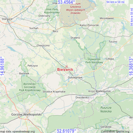
Bierzwnik GPS coordinates[2]
53° 2' 8.412" North, 15° 39' 54" East
| Map corner | latitude | longitude |
|---|---|---|
| Upper-left | 53.4564°, | 14.96188° |
| Center: | 53.03567°, | 15.665° |
| Lower-right: | 52.61079°, | 16.36813° |
| Map W x H: | 94×94 km | = 58.4×58.4mi |
| max Lat: | 54.83135° ⇑15.9% North |
| Bierzwnik: | 53.03567° |
| min Lat: | ⇓84.1% South 49.21328° |
| min Long | Bierzwnik | max Long |
| 14.20249° | 15.665° | 24.03723° |
| W 5.5%⇐ | ⇒94.5% E |
Elevation
Elevation of Bierzwnik is 67 m = 220 ft, and this is 124.4 m = 408 ft below average elevation for this country.
| Max E: |
974 m = 3196 ft | 91.6% |
| Avg. | 191.4 m = 628 ft | |
| Bierzwnik | 67 m = 220 ft | |
Min E: |
-3 m = -10 ft | 8.4% |
See also: Poland elevation on elevation.city.
Geographical zone
Bierzwnik is located in North temperate zone (between Tropic of Cancer and the Arctic Circle). Distance of this North polar circle is 1504.2 km =934.7 mi to North.| Distance of | km | miles | from Bierzwnik |
|---|---|---|---|
| North Pole | 4110 | 2553.8 | to North |
| Arctic Circle | 1504.2 | 934.7 | to North |
| Tropic Cancer | 3291.1 | 2045 | to South |
| Equator | 5897 | 3664.2 | to South |


Nearby cities:
15 places around Bierzwnik: (largest is in red/bold)
• Barlinek
30.2 km =18.8 mi,  261°
261°
• Choszczno
22.1 km =13.7 mi,  312°
312°
• Człopa
31 km =19.3 mi,  79°
79°
• Dobiegniew
9.5 km =5.9 mi,  141°
141°
• Drawno
21.4 km =13.3 mi,  17°
17°
• Drawsko
31.8 km =19.8 mi,  129°
129°
• Drezdenko
24.6 km =15.3 mi,  153°
153°
• Kalisz Pomorski
33.4 km =20.8 mi,  28°
28°
• Krzyż Wielkopolski
28.9 km =18 mi, 126°
• Krzęcin
12.8 km =8 mi,  293°
293°
• Pełczyce
24.1 km =15 mi,  272°
272°
• Recz
26.1 km =16.2 mi,  342°
342°
• Stare Kurowo
19.9 km =12.4 mi,  177°
177°
• Strzelce Krajeńskie
19.8 km =12.3 mi,  207°
207°
• Zwierzyń
23.6 km =14.7 mi,  196°
196°
Sources, notices
• [Note1] Compared only with cities in Poland existing in our database
• [Src1] Map data: © OpenStreetMap contributors (CC-BY-SA)
• [Src2] Other city data from geonames.org with taken over terms of usage.
• [Src3] Geographical zone / Annual Mean Temperature by Robert A. Rohde @ Wikipedia
