Dobiegniew geodata
Dobiegniew (Lubusz) is a seat of a third-order administrative division; located in Poland in Europe/Warsaw (GMT+2) time zone. With population of 3,179 people, there are 999 cities with bigger population in this country. Compared to other cities in Poland, 83.2% of cities are located further ↓South; 93.9% of cities are located further →East and 91.8% of cities have higher elevation than Dobiegniew. Note1
Administrative division(s):
- Level 1: Lubusz
- Level 2: Powiat strzelecko-drezdenecki
- Level 3: Dobiegniew


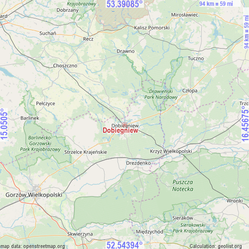
Dobiegniew GPS coordinates[2]
52° 58' 10.092" North, 15° 45' 13.032" East
| Map corner | latitude | longitude |
|---|---|---|
| Upper-left | 53.39085°, | 15.0505° |
| Center: | 52.96947°, | 15.75362° |
| Lower-right: | 52.54394°, | 16.45675° |
| Map W x H: | 94.2×94.2 km | = 58.5×58.5mi |
| max Lat: | 54.83135° ⇑16.8% North |
| Dobiegniew: | 52.96947° |
| min Lat: | ⇓83.2% South 49.21328° |
| min Long | Dobiegniew | max Long |
| 14.20249° | 15.75362° | 24.03723° |
| W 6.1%⇐ | ⇒93.9% E |
Elevation
Elevation of Dobiegniew is 66 m = 217 ft, and this is 125.4 m = 411 ft below average elevation for this country.
| Max E: |
974 m = 3196 ft | 91.8% |
| Avg. | 191.4 m = 628 ft | |
| Dobiegniew | 66 m = 217 ft | |
Min E: |
-3 m = -10 ft | 8.2% |
See also: Poland elevation on elevation.city.
Geographical zone
Dobiegniew is located in North temperate zone (between Tropic of Cancer and the Arctic Circle). Distance of this North polar circle is 1511.5 km =939.2 mi to North.| Distance of | km | miles | from Dobiegniew |
|---|---|---|---|
| North Pole | 4117.4 | 2558.4 | to North |
| Arctic Circle | 1511.5 | 939.2 | to North |
| Tropic Cancer | 3283.7 | 2040.4 | to South |
| Equator | 5889.7 | 3659.7 | to South |


Nearby cities:
15 places around Dobiegniew: (largest is in red/bold)
• Bierzwnik
9.5 km =5.9 mi,  321°
321°
• Choszczno
31.4 km =19.5 mi,  314°
314°
• Człopa
27.9 km =17.3 mi,  61°
61°
• Drawno
27.8 km =17.3 mi,  0°
0°
• Drawsko
22.6 km =14 mi,  124°
124°
• Drezdenko
15.5 km =9.6 mi,  160°
160°
• Gralewo
34.7 km =21.6 mi,  225°
225°
• Krzyż Wielkopolski
19.9 km =12.4 mi, 119°
• Krzęcin
21.6 km =13.4 mi, 305°
• Pełczyce
31.2 km =19.4 mi,  285°
285°
• Santok
34.6 km =21.5 mi,  221°
221°
• Stare Kurowo
13.5 km =8.4 mi,  202°
202°
• Strzelce Krajeńskie
18.2 km =11.3 mi,  235°
235°
• Wieleń
29.2 km =18.1 mi,  106°
106°
• Zwierzyń
19.7 km =12.2 mi, 219°
Sources, notices
• [Note1] Compared only with cities in Poland existing in our database
• [Src1] Map data: © OpenStreetMap contributors (CC-BY-SA)
• [Src2] Other city data from geonames.org with taken over terms of usage.
• [Src3] Geographical zone / Annual Mean Temperature by Robert A. Rohde @ Wikipedia
