Drezdenko geodata
Drezdenko (Lubusz) is a seat of a third-order administrative division; located in Poland in Europe/Warsaw (GMT+2) time zone. With population of 10,541 people, there are 430 cities with bigger population in this country. Compared to other cities in Poland, 81.4% of cities are located further ↓South; 93.4% of cities are located further →East and 96.2% of cities have higher elevation than Drezdenko. Note1
Administrative division(s):
- Level 1: Lubusz
- Level 2: Powiat strzelecko-drezdenecki
- Level 3: Drezdenko


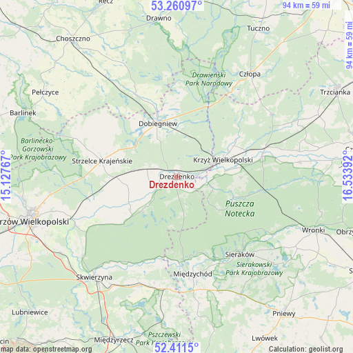
Drezdenko GPS coordinates[2]
52° 50' 17.916" North, 15° 49' 50.844" East
| Map corner | latitude | longitude |
|---|---|---|
| Upper-left | 53.26097°, | 15.12767° |
| Center: | 52.83831°, | 15.83079° |
| Lower-right: | 52.4115°, | 16.53392° |
| Map W x H: | 94.5×94.5 km | = 58.7×58.7mi |
| max Lat: | 54.83135° ⇑18.6% North |
| Drezdenko: | 52.83831° |
| min Lat: | ⇓81.4% South 49.21328° |
| min Long | Drezdenko | max Long |
| 14.20249° | 15.83079° | 24.03723° |
| W 6.6%⇐ | ⇒93.4% E |
Elevation
Elevation of Drezdenko is 30 m = 98 ft, and this is 161.4 m = 530 ft below average elevation for this country.
| Max E: |
974 m = 3196 ft | 96.2% |
| Avg. | 191.4 m = 628 ft | |
| Drezdenko | 30 m = 98 ft | |
Min E: |
-3 m = -10 ft | 3.8% |
See also: Poland elevation on elevation.city.
Geographical zone
Drezdenko is located in North temperate zone (between Tropic of Cancer and the Arctic Circle). Distance of this North polar circle is 1526.1 km =948.3 mi to North.| Distance of | km | miles | from Drezdenko |
|---|---|---|---|
| North Pole | 4132 | 2567.5 | to North |
| Arctic Circle | 1526.1 | 948.3 | to North |
| Tropic Cancer | 3269.2 | 2031.4 | to South |
| Equator | 5875.1 | 3650.6 | to South |


Nearby cities:
15 places around Drezdenko: (largest is in red/bold)
• Bierzwnik
24.6 km =15.3 mi,  333°
333°
• Dobiegniew
15.5 km =9.6 mi,  340°
340°
• Drawsko
13.6 km =8.5 mi,  82°
82°
• Gralewo
31.5 km =19.6 mi,  251°
251°
• Krzyż Wielkopolski
13 km =8.1 mi,  68°
68°
• Lutom
31.6 km =19.6 mi,  138°
138°
• Międzychód
27 km =16.8 mi,  170°
170°
• Przytoczna
30.7 km =19.1 mi,  199°
199°
• Santok
30.4 km =18.9 mi, 248°
• Sieraków
26.7 km =16.6 mi, 141°
• Stare Kurowo
10.5 km =6.5 mi,  281°
281°
• Stare Polichno
30 km =18.6 mi,  243°
243°
• Strzelce Krajeńskie
20.7 km =12.9 mi, 282°
• Wieleń
23.7 km =14.7 mi, 74°
• Zwierzyń
17.7 km =11 mi,  267°
267°
Sources, notices
• [Note1] Compared only with cities in Poland existing in our database
• [Src1] Map data: © OpenStreetMap contributors (CC-BY-SA)
• [Src2] Other city data from geonames.org with taken over terms of usage.
• [Src3] Geographical zone / Annual Mean Temperature by Robert A. Rohde @ Wikipedia
