Kleszczów geodata
Kleszczów (Silesia) is a populated place; located in Poland in Europe/Warsaw (GMT+2) time zone. With population of 781 people, there are 2895 cities with bigger population in this country. Compared to other cities in Poland, 70.9% of cities are located further ↑North; 67.7% of cities are located further →East and 71.6% of cities have lower elevation than Kleszczów. Note1


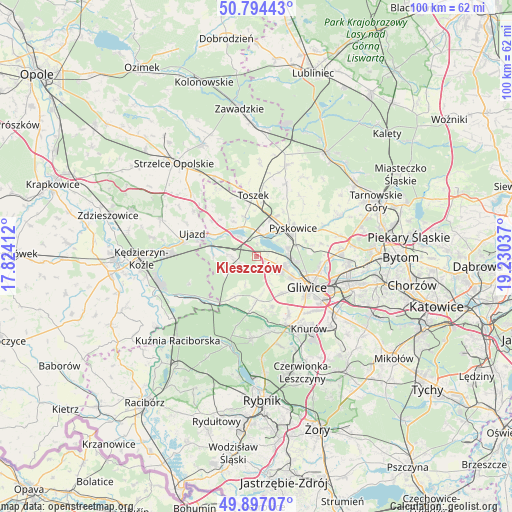
Kleszczów GPS coordinates[2]
50° 20' 52.332" North, 18° 31' 38.064" East
| Map corner | latitude | longitude |
|---|---|---|
| Upper-left | 50.79443°, | 17.82412° |
| Center: | 50.34787°, | 18.52724° |
| Lower-right: | 49.89707°, | 19.23037° |
| Map W x H: | 99.8×99.8 km | = 62×62mi |
| max Lat: | 54.83135° ⇑70.9% North |
| Kleszczów: | 50.34787° |
| min Lat: | ⇓29.1% South 49.21328° |
| min Long | Kleszczów | max Long |
| 14.20249° | 18.52724° | 24.03723° |
| W 32.3%⇐ | ⇒67.7% E |
Elevation
Elevation of Kleszczów is 234 m = 768 ft, and this is 42.6 m = 140 ft above average elevation for this country.
| Max E: |
974 m = 3196 ft | 28.4% |
| Kleszczów | 234 m 768 ft | |
| Avg. | 191.4 m = 628 ft | |
Min E: |
-3 m = -10 ft | 71.6% |
See also: Poland elevation on elevation.city.
Geographical zone
Kleszczów is located in North temperate zone (between Tropic of Cancer and the Arctic Circle). Distance of this North polar circle is 1803 km =1120.3 mi to North.| Distance of | km | miles | from Kleszczów |
|---|---|---|---|
| North Pole | 4408.9 | 2739.6 | to North |
| Arctic Circle | 1803 | 1120.3 | to North |
| Tropic Cancer | 2992.2 | 1859.3 | to South |
| Equator | 5598.2 | 3478.6 | to South |


Nearby cities:
15 places around Kleszczów: (largest is in red/bold)
• Gliwice
12 km =7.5 mi,  117°
117°
• Knurów
16.7 km =10.4 mi,  148°
148°
• Kozłów
5.2 km =3.2 mi, 149°
• Pilchowice
14.8 km =9.2 mi,  170°
170°
• Pyskowice
9.5 km =5.9 mi,  52°
52°
• Rudy
18.3 km =11.4 mi,  196°
196°
• Rudziniec
8.4 km =5.2 mi,  274°
274°
• Sośnicowice
8.4 km =5.2 mi,  178°
178°
• Sławięcice
14.8 km =9.2 mi,  280°
280°
• Toszek
11.9 km =7.4 mi,  358°
358°
• Ujazd
13.4 km =8.3 mi,  290°
290°
• Wieszowa
16.9 km =10.5 mi,  76°
76°
• Wilcza
18.3 km =11.4 mi,  164°
164°
• Zbrosławice
17.8 km =11.1 mi,  64°
64°
• Żernica
12.8 km =8 mi, 150°
Sources, notices
• [Note1] Compared only with cities in Poland existing in our database
• [Src1] Map data: © OpenStreetMap contributors (CC-BY-SA)
• [Src2] Other city data from geonames.org with taken over terms of usage.
• [Src3] Geographical zone / Annual Mean Temperature by Robert A. Rohde @ Wikipedia
