Rudziniec geodata
Rudziniec (Silesia) is a populated place; located in Poland in Europe/Warsaw (GMT+2) time zone. With population of 1,633 people, there are 1731 cities with bigger population in this country. Compared to other cities in Poland, 70.7% of cities are located further ↑North; 69.5% of cities are located further →East and 65.3% of cities have lower elevation than Rudziniec. Note1


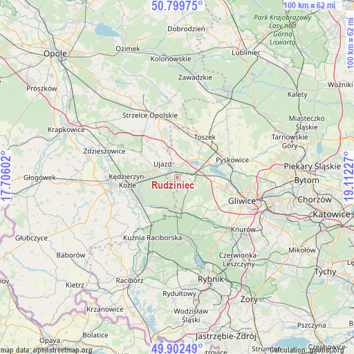
Rudziniec GPS coordinates[2]
50° 21' 11.664" North, 18° 24' 32.904" East
| Map corner | latitude | longitude |
|---|---|---|
| Upper-left | 50.79975°, | 17.70602° |
| Center: | 50.35324°, | 18.40914° |
| Lower-right: | 49.90249°, | 19.11227° |
| Map W x H: | 99.8×99.8 km | = 62×62mi |
| max Lat: | 54.83135° ⇑70.7% North |
| Rudziniec: | 50.35324° |
| min Lat: | ⇓29.3% South 49.21328° |
| min Long | Rudziniec | max Long |
| 14.20249° | 18.40914° | 24.03723° |
| W 30.5%⇐ | ⇒69.5% E |
Elevation
Elevation of Rudziniec is 215 m = 705 ft, and this is 23.6 m = 77 ft above average elevation for this country.
| Max E: |
974 m = 3196 ft | 34.7% |
| Rudziniec | 215 m 705 ft | |
| Avg. | 191.4 m = 628 ft | |
Min E: |
-3 m = -10 ft | 65.3% |
See also: Poland elevation on elevation.city.
Geographical zone
Rudziniec is located in North temperate zone (between Tropic of Cancer and the Arctic Circle). Distance of this North polar circle is 1802.4 km =1120 mi to North.| Distance of | km | miles | from Rudziniec |
|---|---|---|---|
| North Pole | 4408.3 | 2739.2 | to North |
| Arctic Circle | 1802.4 | 1120 | to North |
| Tropic Cancer | 2992.8 | 1859.6 | to South |
| Equator | 5598.8 | 3478.9 | to South |


Nearby cities:
15 places around Rudziniec: (largest is in red/bold)
• Bierawa
14.3 km =8.9 mi,  235°
235°
• Cisek
16.8 km =10.4 mi, 242°
• Dziergowice
15.1 km =9.4 mi,  215°
215°
• Kleszczów
8.4 km =5.2 mi,  94°
94°
• Kozłów
12.1 km =7.5 mi,  114°
114°
• Kuźnia Raciborska
18.3 km =11.4 mi,  202°
202°
• Kędzierzyn-Koźle
13 km =8.1 mi,  268°
268°
• Leśnica
18 km =11.2 mi,  298°
298°
• Lubieszów
14.5 km =9 mi, 224°
• Pyskowice
16.7 km =10.4 mi,  71°
71°
• Raszowa
17.2 km =10.7 mi,  286°
286°
• Sośnicowice
12.4 km =7.7 mi,  136°
136°
• Sławięcice
6.5 km =4 mi, 288°
• Toszek
13.8 km =8.6 mi,  35°
35°
• Ujazd
5.8 km =3.6 mi,  313°
313°
Sources, notices
• [Note1] Compared only with cities in Poland existing in our database
• [Src1] Map data: © OpenStreetMap contributors (CC-BY-SA)
• [Src2] Other city data from geonames.org with taken over terms of usage.
• [Src3] Geographical zone / Annual Mean Temperature by Robert A. Rohde @ Wikipedia
