Pyskowice geodata
Pyskowice (Silesia) is a seat of a third-order administrative division; located in Poland in Europe/Warsaw (GMT+2) time zone. With population of 19,018 people, there are 254 cities with bigger population in this country. Compared to other cities in Poland, 69.5% of cities are located further ↑North; 65.9% of cities are located further →East and 70.9% of cities have lower elevation than Pyskowice. Note1


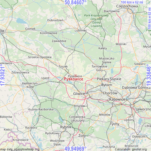
Pyskowice GPS coordinates[2]
50° 24' 0" North, 18° 37' 59.988" East
| Map corner | latitude | longitude |
|---|---|---|
| Upper-left | 50.84607°, | 17.93021° |
| Center: | 50.4°, | 18.63333° |
| Lower-right: | 49.94969°, | 19.33646° |
| Map W x H: | 99.7×99.7 km | = 62×62mi |
| max Lat: | 54.83135° ⇑69.5% North |
| Pyskowice: | 50.4° |
| min Lat: | ⇓30.5% South 49.21328° |
| min Long | Pyskowice | max Long |
| 14.20249° | 18.63333° | 24.03723° |
| W 34.1%⇐ | ⇒65.9% E |
Elevation
Elevation of Pyskowice is 232 m = 761 ft, and this is 40.6 m = 133 ft above average elevation for this country.
| Max E: |
974 m = 3196 ft | 29.1% |
| Pyskowice | 232 m 761 ft | |
| Avg. | 191.4 m = 628 ft | |
Min E: |
-3 m = -10 ft | 70.9% |
See also: Poland elevation on elevation.city.
Geographical zone
Pyskowice is located in North temperate zone (between Tropic of Cancer and the Arctic Circle). Distance of this North polar circle is 1797.2 km =1116.7 mi to North.| Distance of | km | miles | from Pyskowice |
|---|---|---|---|
| North Pole | 4403.1 | 2736 | to North |
| Arctic Circle | 1797.2 | 1116.7 | to North |
| Tropic Cancer | 2998 | 1862.9 | to South |
| Equator | 5604 | 3482.2 | to South |


Nearby cities:
15 places around Pyskowice: (largest is in red/bold)
• Gliwice
11.8 km =7.3 mi,  164°
164°
• Kleszczów
9.5 km =5.9 mi,  232°
232°
• Kozłów
11.4 km =7.1 mi,  205°
205°
• Przyszowice
18.7 km =11.6 mi,  154°
154°
• Radzionków
19.1 km =11.9 mi,  89°
89°
• Rudziniec
16.7 km =10.4 mi,  251°
251°
• Sośnicowice
16 km =9.9 mi, 207°
• Tarnowskie Góry
16.9 km =10.5 mi,  72°
72°
• Toszek
9.9 km =6.2 mi,  307°
307°
• Tworóg
15.7 km =9.8 mi,  21°
21°
• Wielowieś
12.3 km =7.6 mi,  354°
354°
• Wieszowa
9.1 km =5.7 mi,  100°
100°
• Zabrze
13.7 km =8.5 mi,  127°
127°
• Zbrosławice
8.8 km =5.5 mi,  78°
78°
• Żernica
17 km =10.6 mi,  184°
184°
Sources, notices
• [Note1] Compared only with cities in Poland existing in our database
• [Src1] Map data: © OpenStreetMap contributors (CC-BY-SA)
• [Src2] Other city data from geonames.org with taken over terms of usage.
• [Src3] Geographical zone / Annual Mean Temperature by Robert A. Rohde @ Wikipedia
