Słupia pod Kępnem geodata
Słupia pod Kępnem (Greater Poland) is a populated place; located in Poland in Europe/Warsaw (GMT+2) time zone. With population of 1,436 people, there are 1922 cities with bigger population in this country. Compared to other cities in Poland, 51.8% of cities are located further ↓South; 74.8% of cities are located further →East and 56% of cities have lower elevation than Słupia pod Kępnem. Note1


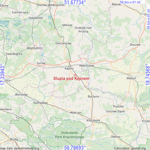
Słupia pod Kępnem GPS coordinates[2]
51° 14' 21.264" North, 18° 2' 33.18" East
| Map corner | latitude | longitude |
|---|---|---|
| Upper-left | 51.67734°, | 17.33943° |
| Center: | 51.23924°, | 18.04255° |
| Lower-right: | 50.79693°, | 18.74568° |
| Map W x H: | 97.9×97.9 km | = 60.8×60.8mi |
| max Lat: | 54.83135° ⇑48.2% North |
| Słupia pod Kępnem: | 51.23924° |
| min Lat: | ⇓51.8% South 49.21328° |
| min Long | Słupia pod Kę | max Long |
| 14.20249° | 18.04255° | 24.03723° |
| W 25.2%⇐ | ⇒74.8% E |
Elevation
Elevation of Słupia pod Kępnem is 188 m = 617 ft, and this is 3.4 m = 11 ft below average elevation for this country.
| Max E: |
974 m = 3196 ft | 44% |
| Avg. | 191.4 m = 628 ft | |
| Słupia pod Kępnem | 188 m = 617 ft | |
Min E: |
-3 m = -10 ft | 56% |
See also: Poland elevation on elevation.city.
Geographical zone
Słupia pod Kępnem is located in North temperate zone (between Tropic of Cancer and the Arctic Circle). Distance of this North polar circle is 1703.9 km =1058.8 mi to North.| Distance of | km | miles | from Słupia pod Kępnem |
|---|---|---|---|
| North Pole | 4309.8 | 2678 | to North |
| Arctic Circle | 1703.9 | 1058.8 | to North |
| Tropic Cancer | 3091.4 | 1920.9 | to South |
| Equator | 5697.3 | 3540.1 | to South |


Nearby cities:
15 places around Słupia pod Kępnem: (largest is in red/bold)
• Baranów
3.8 km =2.4 mi,  315°
315°
• Bolesławiec
11.3 km =7 mi,  113°
113°
• Bralin
11 km =6.8 mi,  298°
298°
• Byczyna
18.4 km =11.4 mi,  139°
139°
• Kępno
5.7 km =3.5 mi, 319°
• Mieleszyn
11.3 km =7 mi,  88°
88°
• Opatów
7.7 km =4.8 mi, 110°
• Osiek
17.9 km =11.1 mi,  37°
37°
• Perzów
16.7 km =10.4 mi,  284°
284°
• Rychtal
16.9 km =10.5 mi,  231°
231°
• Siemianice
9.6 km =6 mi,  133°
133°
• Trzcinica
8.5 km =5.3 mi,  198°
198°
• Wielki Buczek
12.9 km =8 mi, 204°
• Wieruszów
10 km =6.2 mi,  51°
51°
• Łęka Opatowska
5.4 km =3.4 mi,  123°
123°
Sources, notices
• [Note1] Compared only with cities in Poland existing in our database
• [Src1] Map data: © OpenStreetMap contributors (CC-BY-SA)
• [Src2] Other city data from geonames.org with taken over terms of usage.
• [Src3] Geographical zone / Annual Mean Temperature by Robert A. Rohde @ Wikipedia
