Bralin geodata
Bralin (Greater Poland) is a seat of a third-order administrative division; located in Poland in Europe/Warsaw (GMT+2) time zone. With population of 2,500 people, there are 1240 cities with bigger population in this country. Compared to other cities in Poland, 52.8% of cities are located further ↓South; 76.2% of cities are located further →East and 53.5% of cities have lower elevation than Bralin. Note1


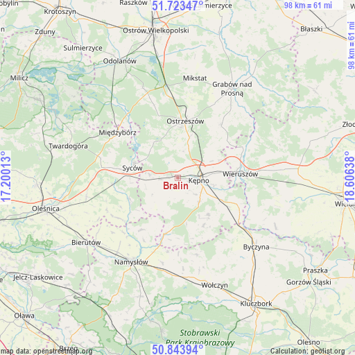
Bralin GPS coordinates[2]
51° 17' 8.916" North, 17° 54' 11.7" East
| Map corner | latitude | longitude |
|---|---|---|
| Upper-left | 51.72347°, | 17.20013° |
| Center: | 51.28581°, | 17.90325° |
| Lower-right: | 50.84394°, | 18.60638° |
| Map W x H: | 97.8×97.8 km | = 60.8×60.8mi |
| max Lat: | 54.83135° ⇑47.2% North |
| Bralin: | 51.28581° |
| min Lat: | ⇓52.8% South 49.21328° |
| min Long | Bralin | max Long |
| 14.20249° | 17.90325° | 24.03723° |
| W 23.8%⇐ | ⇒76.2% E |
Elevation
Elevation of Bralin is 181 m = 594 ft, and this is 10.4 m = 34 ft below average elevation for this country.
| Max E: |
974 m = 3196 ft | 46.5% |
| Avg. | 191.4 m = 628 ft | |
| Bralin | 181 m = 594 ft | |
Min E: |
-3 m = -10 ft | 53.5% |
See also: Poland elevation on elevation.city.
Geographical zone
Bralin is located in North temperate zone (between Tropic of Cancer and the Arctic Circle). Distance of this North polar circle is 1698.7 km =1055.5 mi to North.| Distance of | km | miles | from Bralin |
|---|---|---|---|
| North Pole | 4304.6 | 2674.8 | to North |
| Arctic Circle | 1698.7 | 1055.5 | to North |
| Tropic Cancer | 3096.5 | 1924.1 | to South |
| Equator | 5702.4 | 3543.3 | to South |


Nearby cities:
15 places around Bralin: (largest is in red/bold)
• Baranów
7.5 km =4.7 mi,  109°
109°
• Dziadowa Kłoda
14.6 km =9.1 mi,  247°
247°
• Kobyla Góra
11.3 km =7 mi,  336°
336°
• Kępno
6 km =3.7 mi,  97°
97°
• Miechów
9.2 km =5.7 mi, 249°
• Opatów
18.7 km =11.6 mi,  115°
115°
• Ostrzeszów
15.8 km =9.8 mi,  7°
7°
• Perzów
6.6 km =4.1 mi,  260°
260°
• Rychtal
16 km =9.9 mi,  193°
193°
• Syców
13 km =8.1 mi,  281°
281°
• Słupia pod Kępnem
11 km =6.8 mi, 118°
• Trzcinica
15 km =9.3 mi,  151°
151°
• Wielki Buczek
17.4 km =10.8 mi,  165°
165°
• Wieruszów
17.6 km =10.9 mi,  86°
86°
• Łęka Opatowska
16.4 km =10.2 mi, 119°
Sources, notices
• [Note1] Compared only with cities in Poland existing in our database
• [Src1] Map data: © OpenStreetMap contributors (CC-BY-SA)
• [Src2] Other city data from geonames.org with taken over terms of usage.
• [Src3] Geographical zone / Annual Mean Temperature by Robert A. Rohde @ Wikipedia
