Kępno geodata
Kępno (Greater Poland) is a seat of a second-order administrative division; located in Poland in Europe/Warsaw (GMT+2) time zone. With population of 14,813 people, there are 338 cities with bigger population in this country. Compared to other cities in Poland, 52.7% of cities are located further ↓South; 75.4% of cities are located further →East and 50.2% of cities have higher elevation than Kępno. Note1


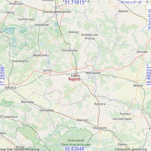
Kępno GPS coordinates[2]
51° 16' 42.24" North, 17° 59' 20.688" East
| Map corner | latitude | longitude |
|---|---|---|
| Upper-left | 51.71613°, | 17.28596° |
| Center: | 51.2784°, | 17.98908° |
| Lower-right: | 50.83646°, | 18.69221° |
| Map W x H: | 97.8×97.8 km | = 60.8×60.8mi |
| max Lat: | 54.83135° ⇑47.3% North |
| Kępno: | 51.2784° |
| min Lat: | ⇓52.7% South 49.21328° |
| min Long | Kępno | max Long |
| 14.20249° | 17.98908° | 24.03723° |
| W 24.6%⇐ | ⇒75.4% E |
Elevation
Elevation of Kępno is 171 m = 561 ft, and this is 20.4 m = 67 ft below average elevation for this country.
| Max E: |
974 m = 3196 ft | 50.2% |
| Avg. | 191.4 m = 628 ft | |
| Kępno | 171 m = 561 ft | |
Min E: |
-3 m = -10 ft | 49.8% |
See also: Poland elevation on elevation.city.
Geographical zone
Kępno is located in North temperate zone (between Tropic of Cancer and the Arctic Circle). Distance of this North polar circle is 1699.6 km =1056.1 mi to North.| Distance of | km | miles | from Kępno |
|---|---|---|---|
| North Pole | 4305.4 | 2675.3 | to North |
| Arctic Circle | 1699.6 | 1056.1 | to North |
| Tropic Cancer | 3095.7 | 1923.6 | to South |
| Equator | 5701.6 | 3542.8 | to South |


Nearby cities:
15 places around Kępno: (largest is in red/bold)
• Baranów
2 km =1.2 mi,  146°
146°
• Bolesławiec
16.6 km =10.3 mi,  122°
122°
• Bralin
6 km =3.7 mi,  277°
277°
• Doruchów
16.6 km =10.3 mi,  21°
21°
• Kobyla Góra
15.4 km =9.6 mi,  316°
316°
• Miechów
14.8 km =9.2 mi,  260°
260°
• Mieleszyn
15.5 km =9.6 mi,  105°
105°
• Opatów
13 km =8.1 mi, 122°
• Perzów
12.5 km =7.8 mi,  268°
268°
• Siemianice
15.4 km =9.6 mi,  135°
135°
• Słupia pod Kępnem
5.7 km =3.5 mi, 139°
• Trzcinica
12.4 km =7.7 mi,  175°
175°
• Wielki Buczek
16.1 km =10 mi,  185°
185°
• Wieruszów
11.7 km =7.3 mi,  81°
81°
• Łęka Opatowska
11 km =6.8 mi,  131°
131°
Sources, notices
• [Note1] Compared only with cities in Poland existing in our database
• [Src1] Map data: © OpenStreetMap contributors (CC-BY-SA)
• [Src2] Other city data from geonames.org with taken over terms of usage.
• [Src3] Geographical zone / Annual Mean Temperature by Robert A. Rohde @ Wikipedia
