Trzcinica geodata
Trzcinica (Greater Poland) is a seat of a third-order administrative division; located in Poland in Europe/Warsaw (GMT+2) time zone. With population of 1,158 people, there are 2250 cities with bigger population in this country. Compared to other cities in Poland, 50.1% of cities are located further ↓South; 75.2% of cities are located further →East and 54.4% of cities have lower elevation than Trzcinica. Note1


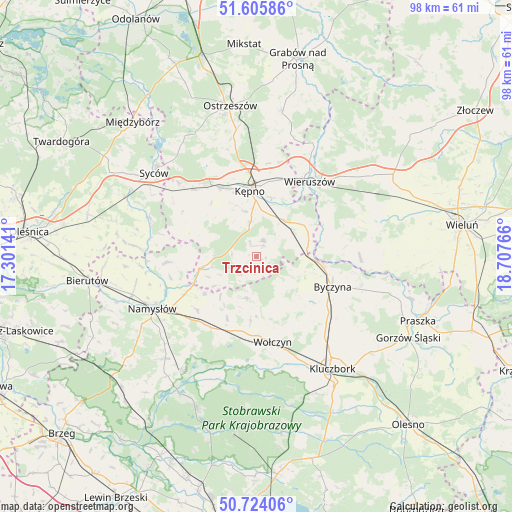
Trzcinica GPS coordinates[2]
51° 10' 1.452" North, 18° 0' 16.308" East
| Map corner | latitude | longitude |
|---|---|---|
| Upper-left | 51.60586°, | 17.30141° |
| Center: | 51.16707°, | 18.00453° |
| Lower-right: | 50.72406°, | 18.70766° |
| Map W x H: | 98×98 km | = 60.9×60.9mi |
| max Lat: | 54.83135° ⇑49.9% North |
| Trzcinica: | 51.16707° |
| min Lat: | ⇓50.1% South 49.21328° |
| min Long | Trzcinica | max Long |
| 14.20249° | 18.00453° | 24.03723° |
| W 24.8%⇐ | ⇒75.2% E |
Elevation
Elevation of Trzcinica is 183 m = 600 ft, and this is 8.4 m = 28 ft below average elevation for this country.
| Max E: |
974 m = 3196 ft | 45.6% |
| Avg. | 191.4 m = 628 ft | |
| Trzcinica | 183 m = 600 ft | |
Min E: |
-3 m = -10 ft | 54.4% |
See also: Poland elevation on elevation.city.
Geographical zone
Trzcinica is located in North temperate zone (between Tropic of Cancer and the Arctic Circle). Distance of this North polar circle is 1711.9 km =1063.7 mi to North.| Distance of | km | miles | from Trzcinica |
|---|---|---|---|
| North Pole | 4317.8 | 2683 | to North |
| Arctic Circle | 1711.9 | 1063.7 | to North |
| Tropic Cancer | 3083.3 | 1915.9 | to South |
| Equator | 5689.2 | 3535.1 | to South |


Nearby cities:
15 places around Trzcinica: (largest is in red/bold)
• Baranów
10.7 km =6.6 mi,  0°
0°
• Bolesławiec
13.5 km =8.4 mi,  74°
74°
• Bralin
15 km =9.3 mi,  331°
331°
• Byczyna
15.8 km =9.8 mi,  112°
112°
• Domaszowice
16 km =9.9 mi,  210°
210°
• Kępno
12.4 km =7.7 mi,  355°
355°
• Mieleszyn
16.2 km =10.1 mi,  59°
59°
• Opatów
11.2 km =7 mi, 61°
• Rychtal
11 km =6.8 mi,  257°
257°
• Siemianice
9.8 km =6.1 mi,  81°
81°
• Strzelce
15.1 km =9.4 mi,  221°
221°
• Słupia pod Kępnem
8.5 km =5.3 mi,  18°
18°
• Wielki Buczek
4.6 km =2.9 mi, 216°
• Wołczyn
16.8 km =10.4 mi,  169°
169°
• Łęka Opatowska
8.7 km =5.4 mi,  54°
54°
Sources, notices
• [Note1] Compared only with cities in Poland existing in our database
• [Src1] Map data: © OpenStreetMap contributors (CC-BY-SA)
• [Src2] Other city data from geonames.org with taken over terms of usage.
• [Src3] Geographical zone / Annual Mean Temperature by Robert A. Rohde @ Wikipedia
