Skulsk geodata
Skulsk (Greater Poland) is a seat of a third-order administrative division; located in Poland in Europe/Warsaw (GMT+2) time zone. With population of 1,400 people, there are 1959 cities with bigger population in this country. Compared to other cities in Poland, 76.2% of cities are located further ↓South; 70.8% of cities are located further →East and 85.7% of cities have higher elevation than Skulsk. Note1


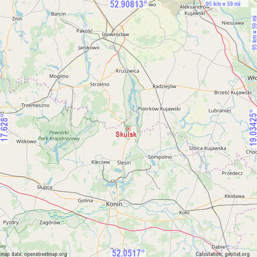
Skulsk GPS coordinates[2]
52° 28' 55.2" North, 18° 19' 52.032" East
| Map corner | latitude | longitude |
|---|---|---|
| Upper-left | 52.90813°, | 17.628° |
| Center: | 52.482°, | 18.33112° |
| Lower-right: | 52.0517°, | 19.03425° |
| Map W x H: | 95.2×95.2 km | = 59.2×59.2mi |
| max Lat: | 54.83135° ⇑23.8% North |
| Skulsk: | 52.482° |
| min Lat: | ⇓76.2% South 49.21328° |
| min Long | Skulsk | max Long |
| 14.20249° | 18.33112° | 24.03723° |
| W 29.2%⇐ | ⇒70.8% E |
Elevation
Elevation of Skulsk is 88 m = 289 ft, and this is 103.4 m = 339 ft below average elevation for this country.
| Max E: |
974 m = 3196 ft | 85.7% |
| Avg. | 191.4 m = 628 ft | |
| Skulsk | 88 m = 289 ft | |
Min E: |
-3 m = -10 ft | 14.3% |
See also: Poland elevation on elevation.city.
Geographical zone
Skulsk is located in North temperate zone (between Tropic of Cancer and the Arctic Circle). Distance of this North polar circle is 1565.7 km =972.9 mi to North.| Distance of | km | miles | from Skulsk |
|---|---|---|---|
| North Pole | 4171.6 | 2592.1 | to North |
| Arctic Circle | 1565.7 | 972.9 | to North |
| Tropic Cancer | 3229.5 | 2006.7 | to South |
| Equator | 5835.5 | 3626 | to South |


Nearby cities:
15 places around Skulsk: (largest is in red/bold)
• Bytoń
19.7 km =12.2 mi,  64°
64°
• Jeziora Wielkie
6.9 km =4.3 mi,  321°
321°
• Kleczew
16.2 km =10.1 mi,  220°
220°
• Kruszwica
21.5 km =13.4 mi,  0°
0°
• Licheń Stary
18.9 km =11.7 mi,  175°
175°
• Orchowo
21.6 km =13.4 mi,  278°
278°
• Piotrków Kujawski
13.7 km =8.5 mi, 55°
• Police
16 km =9.9 mi,  144°
144°
• Radziejów
20.7 km =12.9 mi,  39°
39°
• Sompolno
15.6 km =9.7 mi,  131°
131°
• Strzelno
19.4 km =12.1 mi,  326°
326°
• Wierzbinek
13 km =8.1 mi,  110°
110°
• Wilczogóra
11.1 km =6.9 mi,  265°
265°
• Wilczyn
11.5 km =7.1 mi, 273°
• Ślesin
12.5 km =7.8 mi,  187°
187°
Sources, notices
• [Note1] Compared only with cities in Poland existing in our database
• [Src1] Map data: © OpenStreetMap contributors (CC-BY-SA)
• [Src2] Other city data from geonames.org with taken over terms of usage.
• [Src3] Geographical zone / Annual Mean Temperature by Robert A. Rohde @ Wikipedia
