Wierzbinek geodata
Wierzbinek (Greater Poland) is a seat of a third-order administrative division; located in Poland in Europe/Warsaw (GMT+2) time zone. With population of 380 people, there are 3602 cities with bigger population in this country. Compared to other cities in Poland, 75.5% of cities are located further ↓South; 67.9% of cities are located further →East and 83.7% of cities have higher elevation than Wierzbinek. Note1


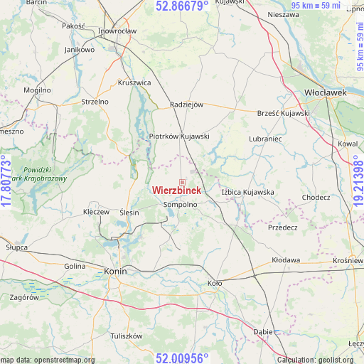
Wierzbinek GPS coordinates[2]
52° 26' 24.936" North, 18° 30' 39.06" East
| Map corner | latitude | longitude |
|---|---|---|
| Upper-left | 52.86679°, | 17.80773° |
| Center: | 52.44026°, | 18.51085° |
| Lower-right: | 52.00956°, | 19.21398° |
| Map W x H: | 95.3×95.3 km | = 59.2×59.2mi |
| max Lat: | 54.83135° ⇑24.5% North |
| Wierzbinek: | 52.44026° |
| min Lat: | ⇓75.5% South 49.21328° |
| min Long | Wierzbinek | max Long |
| 14.20249° | 18.51085° | 24.03723° |
| W 32.1%⇐ | ⇒67.9% E |
Elevation
Elevation of Wierzbinek is 92 m = 302 ft, and this is 99.4 m = 326 ft below average elevation for this country.
| Max E: |
974 m = 3196 ft | 83.7% |
| Avg. | 191.4 m = 628 ft | |
| Wierzbinek | 92 m = 302 ft | |
Min E: |
-3 m = -10 ft | 16.3% |
See also: Poland elevation on elevation.city.
Geographical zone
Wierzbinek is located in North temperate zone (between Tropic of Cancer and the Arctic Circle). Distance of this North polar circle is 1570.4 km =975.8 mi to North.| Distance of | km | miles | from Wierzbinek |
|---|---|---|---|
| North Pole | 4176.3 | 2595 | to North |
| Arctic Circle | 1570.4 | 975.8 | to North |
| Tropic Cancer | 3224.9 | 2003.9 | to South |
| Equator | 5830.8 | 3623.1 | to South |


Nearby cities:
15 places around Wierzbinek: (largest is in red/bold)
• Babiak
14.9 km =9.3 mi,  134°
134°
• Brdów
17.7 km =11 mi,  122°
122°
• Bytoń
14.2 km =8.8 mi,  23°
23°
• Izbica Kujawska
17.2 km =10.7 mi,  97°
97°
• Jeziora Wielkie
19.3 km =12 mi,  301°
301°
• Kramsk
20.4 km =12.7 mi,  196°
196°
• Licheń Stary
17.7 km =11 mi,  216°
216°
• Osiek Mały
19.3 km =12 mi,  161°
161°
• Piotrków Kujawski
12.4 km =7.7 mi,  356°
356°
• Police
8.8 km =5.5 mi, 198°
• Radziejów
20.6 km =12.8 mi,  3°
3°
• Skulsk
13 km =8.1 mi,  290°
290°
• Sompolno
5.8 km =3.6 mi,  185°
185°
• Topólka
15.3 km =9.5 mi,  62°
62°
• Ślesin
15.9 km =9.9 mi,  240°
240°
Sources, notices
• [Note1] Compared only with cities in Poland existing in our database
• [Src1] Map data: © OpenStreetMap contributors (CC-BY-SA)
• [Src2] Other city data from geonames.org with taken over terms of usage.
• [Src3] Geographical zone / Annual Mean Temperature by Robert A. Rohde @ Wikipedia
