Radziejów geodata
Radziejów (Kujawsko-Pomorskie) is a seat of a second-order administrative division; located in Poland in Europe/Warsaw (GMT+2) time zone. With population of 5,759 people, there are 624 cities with bigger population in this country. Compared to other cities in Poland, 78.2% of cities are located further ↓South; 67.7% of cities are located further →East and 73.5% of cities have higher elevation than Radziejów. Note1
Administrative division(s):
- Level 1: Kujawsko-Pomorskie
- Level 2: Powiat radziejowski
- Level 3: Radziejów


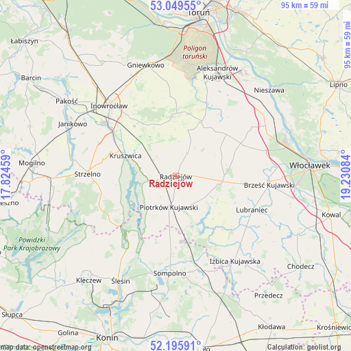
Radziejów GPS coordinates[2]
52° 37' 29.316" North, 18° 31' 39.756" East
| Map corner | latitude | longitude |
|---|---|---|
| Upper-left | 53.04955°, | 17.82459° |
| Center: | 52.62481°, | 18.52771° |
| Lower-right: | 52.19591°, | 19.23084° |
| Map W x H: | 94.9×94.9 km | = 59×59mi |
| max Lat: | 54.83135° ⇑21.8% North |
| Radziejów: | 52.62481° |
| min Lat: | ⇓78.2% South 49.21328° |
| min Long | Radziejów | max Long |
| 14.20249° | 18.52771° | 24.03723° |
| W 32.3%⇐ | ⇒67.7% E |
Elevation
Elevation of Radziejów is 114 m = 374 ft, and this is 77.4 m = 254 ft below average elevation for this country.
| Max E: |
974 m = 3196 ft | 73.5% |
| Avg. | 191.4 m = 628 ft | |
| Radziejów | 114 m = 374 ft | |
Min E: |
-3 m = -10 ft | 26.5% |
See also: Poland elevation on elevation.city.
Geographical zone
Radziejów is located in North temperate zone (between Tropic of Cancer and the Arctic Circle). Distance of this North polar circle is 1549.8 km =963 mi to North.| Distance of | km | miles | from Radziejów |
|---|---|---|---|
| North Pole | 4155.7 | 2582.2 | to North |
| Arctic Circle | 1549.8 | 963 | to North |
| Tropic Cancer | 3245.4 | 2016.6 | to South |
| Equator | 5851.3 | 3635.8 | to South |


Nearby cities:
15 places around Radziejów: (largest is in red/bold)
• Bytoń
8.8 km =5.5 mi,  148°
148°
• Bądkowo
19.7 km =12.2 mi,  63°
63°
• Dobre
7.4 km =4.6 mi,  27°
27°
• Dąbrowa Biskupia
17.1 km =10.6 mi,  3°
3°
• Jeziora Wielkie
20.4 km =12.7 mi,  239°
239°
• Koneck
21.8 km =13.5 mi,  36°
36°
• Kruszwica
14.4 km =8.9 mi,  293°
293°
• Lubraniec
22.6 km =14 mi,  114°
114°
• Osięciny
13.1 km =8.1 mi,  87°
87°
• Piotrków Kujawski
8.4 km =5.2 mi,  193°
193°
• Skulsk
20.7 km =12.9 mi,  219°
219°
• Strzelno
24 km =14.9 mi,  270°
270°
• Topólka
18.4 km =11.4 mi,  137°
137°
• Wierzbinek
20.6 km =12.8 mi,  183°
183°
• Zakrzewo
16.5 km =10.3 mi, 25°
Sources, notices
• [Note1] Compared only with cities in Poland existing in our database
• [Src1] Map data: © OpenStreetMap contributors (CC-BY-SA)
• [Src2] Other city data from geonames.org with taken over terms of usage.
• [Src3] Geographical zone / Annual Mean Temperature by Robert A. Rohde @ Wikipedia
