Bytoń geodata
Bytoń (Kujawsko-Pomorskie) is a seat of a third-order administrative division; located in Poland in Europe/Warsaw (GMT+2) time zone. With population of 436 people, there are 3575 cities with bigger population in this country. Compared to other cities in Poland, 77.2% of cities are located further ↓South; 66.8% of cities are located further →East and 81.2% of cities have higher elevation than Bytoń. Note1


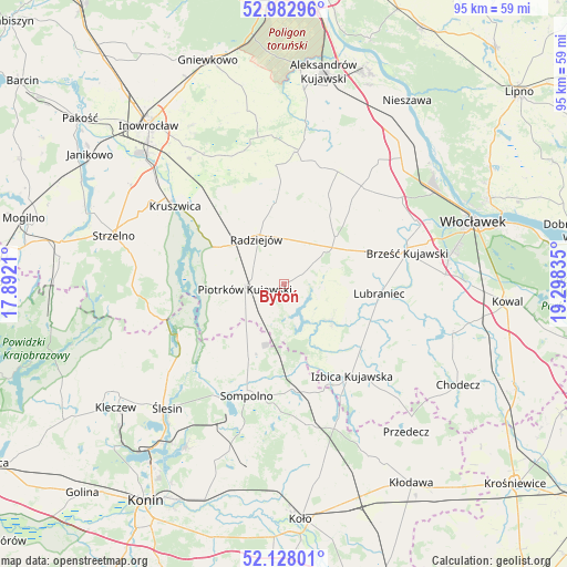
Bytoń GPS coordinates[2]
52° 33' 27.252" North, 18° 35' 42.792" East
| Map corner | latitude | longitude |
|---|---|---|
| Upper-left | 52.98296°, | 17.8921° |
| Center: | 52.55757°, | 18.59522° |
| Lower-right: | 52.12801°, | 19.29835° |
| Map W x H: | 95.1×95.1 km | = 59.1×59.1mi |
| max Lat: | 54.83135° ⇑22.8% North |
| Bytoń: | 52.55757° |
| min Lat: | ⇓77.2% South 49.21328° |
| min Long | Bytoń | max Long |
| 14.20249° | 18.59522° | 24.03723° |
| W 33.2%⇐ | ⇒66.8% E |
Elevation
Elevation of Bytoń is 97 m = 318 ft, and this is 94.4 m = 310 ft below average elevation for this country.
| Max E: |
974 m = 3196 ft | 81.2% |
| Avg. | 191.4 m = 628 ft | |
| Bytoń | 97 m = 318 ft | |
Min E: |
-3 m = -10 ft | 18.8% |
See also: Poland elevation on elevation.city.
Geographical zone
Bytoń is located in North temperate zone (between Tropic of Cancer and the Arctic Circle). Distance of this North polar circle is 1557.3 km =967.7 mi to North.| Distance of | km | miles | from Bytoń |
|---|---|---|---|
| North Pole | 4163.2 | 2586.9 | to North |
| Arctic Circle | 1557.3 | 967.7 | to North |
| Tropic Cancer | 3237.9 | 2011.9 | to South |
| Equator | 5843.9 | 3631.2 | to South |


Nearby cities:
15 places around Bytoń: (largest is in red/bold)
• Brześć Kujawski
21.4 km =13.3 mi,  75°
75°
• Bądkowo
20.9 km =13 mi,  38°
38°
• Dobre
14.1 km =8.8 mi,  355°
355°
• Izbica Kujawska
19 km =11.8 mi,  143°
143°
• Jeziora Wielkie
22.3 km =13.9 mi,  262°
262°
• Kruszwica
22.1 km =13.7 mi,  306°
306°
• Lubraniec
16.1 km =10 mi,  96°
96°
• Osięciny
11.7 km =7.3 mi,  47°
47°
• Piotrków Kujawski
6.5 km =4 mi, 263°
• Radziejów
8.8 km =5.5 mi,  328°
328°
• Skulsk
19.7 km =12.2 mi,  244°
244°
• Sompolno
19.8 km =12.3 mi,  198°
198°
• Topólka
10 km =6.2 mi,  127°
127°
• Wierzbinek
14.2 km =8.8 mi, 203°
• Zakrzewo
22.5 km =14 mi,  6°
6°
Sources, notices
• [Note1] Compared only with cities in Poland existing in our database
• [Src1] Map data: © OpenStreetMap contributors (CC-BY-SA)
• [Src2] Other city data from geonames.org with taken over terms of usage.
• [Src3] Geographical zone / Annual Mean Temperature by Robert A. Rohde @ Wikipedia
