Piotrków Kujawski geodata
Piotrków Kujawski (Kujawsko-Pomorskie) is a seat of a third-order administrative division; located in Poland in Europe/Warsaw (GMT+2) time zone. With population of 5,030 people, there are 686 cities with bigger population in this country. Compared to other cities in Poland, 77.1% of cities are located further ↓South; 68.2% of cities are located further →East and 78.4% of cities have higher elevation than Piotrków Kujawski. Note1
Administrative division(s):
- Level 1: Kujawsko-Pomorskie
- Level 2: Powiat radziejowski
- Level 3: Piotrków Kujawski


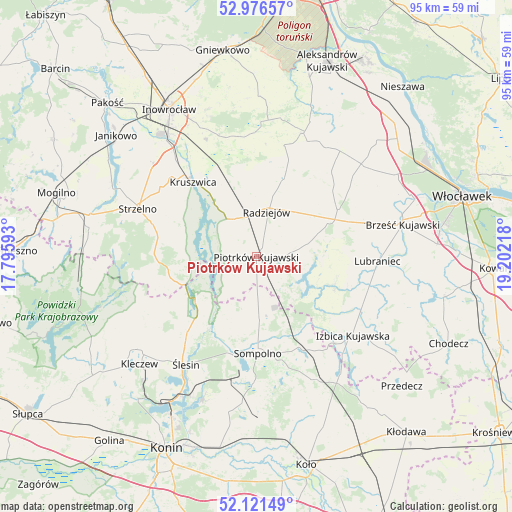
Piotrków Kujawski GPS coordinates[2]
52° 33' 3.996" North, 18° 29' 56.58" East
| Map corner | latitude | longitude |
|---|---|---|
| Upper-left | 52.97657°, | 17.79593° |
| Center: | 52.55111°, | 18.49905° |
| Lower-right: | 52.12149°, | 19.20218° |
| Map W x H: | 95.1×95.1 km | = 59.1×59.1mi |
| max Lat: | 54.83135° ⇑22.9% North |
| Piotrków Kujawski: | 52.55111° |
| min Lat: | ⇓77.1% South 49.21328° |
| min Long | Piotrków Kujaw | max Long |
| 14.20249° | 18.49905° | 24.03723° |
| W 31.8%⇐ | ⇒68.2% E |
Elevation
Elevation of Piotrków Kujawski is 103 m = 338 ft, and this is 88.4 m = 290 ft below average elevation for this country.
| Max E: |
974 m = 3196 ft | 78.4% |
| Avg. | 191.4 m = 628 ft | |
| Piotrków Kujawski | 103 m = 338 ft | |
Min E: |
-3 m = -10 ft | 21.6% |
See also: Poland elevation on elevation.city.
Geographical zone
Piotrków Kujawski is located in North temperate zone (between Tropic of Cancer and the Arctic Circle). Distance of this North polar circle is 1558 km =968.1 mi to North.| Distance of | km | miles | from Piotrków Kujawski |
|---|---|---|---|
| North Pole | 4163.9 | 2587.3 | to North |
| Arctic Circle | 1558 | 968.1 | to North |
| Tropic Cancer | 3237.2 | 2011.5 | to South |
| Equator | 5843.1 | 3630.7 | to South |


Nearby cities:
15 places around Piotrków Kujawski: (largest is in red/bold)
• Bytoń
6.5 km =4 mi,  83°
83°
• Dobre
15.7 km =9.8 mi,  19°
19°
• Izbica Kujawska
23 km =14.3 mi,  129°
129°
• Jeziora Wielkie
15.8 km =9.8 mi,  261°
261°
• Kruszwica
17.9 km =11.1 mi,  320°
320°
• Lubraniec
22.6 km =14 mi,  92°
92°
• Osięciny
17.4 km =10.8 mi,  60°
60°
• Police
20.8 km =12.9 mi,  185°
185°
• Radziejów
8.4 km =5.2 mi,  13°
13°
• Skulsk
13.7 km =8.5 mi,  235°
235°
• Sompolno
18.1 km =11.2 mi,  179°
179°
• Strzelno
23.7 km =14.7 mi,  291°
291°
• Topólka
15.4 km =9.6 mi,  110°
110°
• Wierzbinek
12.4 km =7.7 mi, 176°
• Wilczyn
23.9 km =14.9 mi,  252°
252°
Sources, notices
• [Note1] Compared only with cities in Poland existing in our database
• [Src1] Map data: © OpenStreetMap contributors (CC-BY-SA)
• [Src2] Other city data from geonames.org with taken over terms of usage.
• [Src3] Geographical zone / Annual Mean Temperature by Robert A. Rohde @ Wikipedia
