Sierpc geodata
Sierpc (Mazovia) is a seat of a second-order administrative division; located in Poland in Europe/Warsaw (GMT+2) time zone. With population of 18,866 people, there are 256 cities with bigger population in this country. Compared to other cities in Poland, 81.7% of cities are located further ↓South; 52% of cities are located further ←West and 76.9% of cities have higher elevation than Sierpc. Note1


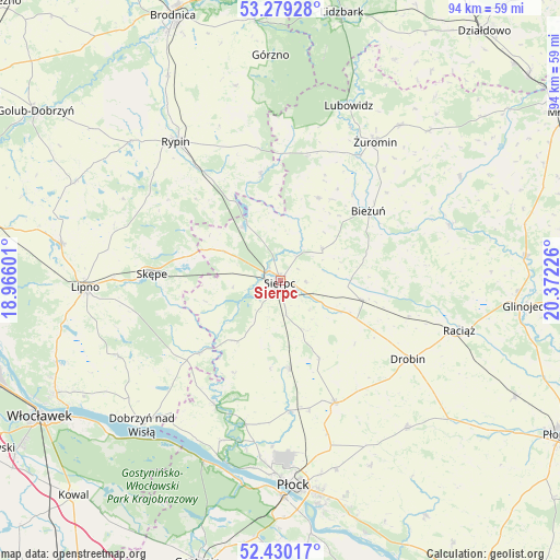
Sierpc GPS coordinates[2]
52° 51' 24.48" North, 19° 40' 8.868" East
| Map corner | latitude | longitude |
|---|---|---|
| Upper-left | 53.27928°, | 18.96601° |
| Center: | 52.8568°, | 19.66913° |
| Lower-right: | 52.43017°, | 20.37226° |
| Map W x H: | 94.4×94.4 km | = 58.7×58.7mi |
| max Lat: | 54.83135° ⇑18.3% North |
| Sierpc: | 52.8568° |
| min Lat: | ⇓81.7% South 49.21328° |
| min Long | Sierpc | max Long |
| 14.20249° | 19.66913° | 24.03723° |
| W 52%⇐ | ⇒48% E |
Elevation
Elevation of Sierpc is 106 m = 348 ft, and this is 85.4 m = 280 ft below average elevation for this country.
| Max E: |
974 m = 3196 ft | 76.9% |
| Avg. | 191.4 m = 628 ft | |
| Sierpc | 106 m = 348 ft | |
Min E: |
-3 m = -10 ft | 23.1% |
See also: Poland elevation on elevation.city.
Geographical zone
Sierpc is located in North temperate zone (between Tropic of Cancer and the Arctic Circle). Distance of this North polar circle is 1524 km =947 mi to North.| Distance of | km | miles | from Sierpc |
|---|---|---|---|
| North Pole | 4129.9 | 2566.2 | to North |
| Arctic Circle | 1524 | 947 | to North |
| Tropic Cancer | 3271.2 | 2032.6 | to South |
| Equator | 5877.1 | 3651.9 | to South |


Nearby cities:
15 places around Sierpc: (largest is in red/bold)
• Bielsk
22.5 km =14 mi,  156°
156°
• Bieżuń
18.8 km =11.7 mi,  51°
51°
• Brudzeń Duży
23.7 km =14.7 mi,  207°
207°
• Drobin
25.3 km =15.7 mi,  121°
121°
• Gozdowo
14.7 km =9.1 mi,  175°
175°
• Lutocin
15.3 km =9.5 mi,  25°
25°
• Mochowo
12.7 km =7.9 mi,  216°
216°
• Rogowo
23.3 km =14.5 mi,  305°
305°
• Rościszewo
8.7 km =5.4 mi, 53°
• Siemiątkowo
24.3 km =15.1 mi,  83°
83°
• Skrwilno
18 km =11.2 mi,  350°
350°
• Skępe
21.1 km =13.1 mi,  273°
273°
• Szczutowo
11.3 km =7 mi,  325°
325°
• Tłuchowo
18.3 km =11.4 mi,  228°
228°
• Zawidz
14.1 km =8.8 mi,  103°
103°
Sources, notices
• [Note1] Compared only with cities in Poland existing in our database
• [Src1] Map data: © OpenStreetMap contributors (CC-BY-SA)
• [Src2] Other city data from geonames.org with taken over terms of usage.
• [Src3] Geographical zone / Annual Mean Temperature by Robert A. Rohde @ Wikipedia
