Sierakowice geodata
Sierakowice (Pomerania) is a populated place; located in Poland in Europe/Warsaw (GMT+2) time zone. With population of 7,068 people, there are 534 cities with bigger population in this country. Compared to other cities in Poland, 98% of cities are located further ↓South; 76.3% of cities are located further →East and 65.3% of cities have lower elevation than Sierakowice. Note1


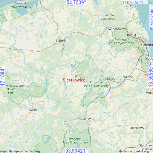
Sierakowice GPS coordinates[2]
54° 20' 45.96" North, 17° 53' 33.072" East
| Map corner | latitude | longitude |
|---|---|---|
| Upper-left | 54.7539°, | 17.1894° |
| Center: | 54.3461°, | 17.89252° |
| Lower-right: | 53.93421°, | 18.59565° |
| Map W x H: | 91.1×91.1 km | = 56.6×56.6mi |
| max Lat: | 54.83135° ⇑2% North |
| Sierakowice: | 54.3461° |
| min Lat: | ⇓98% South 49.21328° |
| min Long | Sierakowice | max Long |
| 14.20249° | 17.89252° | 24.03723° |
| W 23.7%⇐ | ⇒76.3% E |
Elevation
Elevation of Sierakowice is 215 m = 705 ft, and this is 23.6 m = 77 ft above average elevation for this country.
| Max E: |
974 m = 3196 ft | 34.7% |
| Sierakowice | 215 m 705 ft | |
| Avg. | 191.4 m = 628 ft | |
Min E: |
-3 m = -10 ft | 65.3% |
See also: Poland elevation on elevation.city.
Geographical zone
Sierakowice is located in North temperate zone (between Tropic of Cancer and the Arctic Circle). Distance of this North polar circle is 1358.5 km =844.1 mi to North.| Distance of | km | miles | from Sierakowice |
|---|---|---|---|
| North Pole | 3964.3 | 2463.3 | to North |
| Arctic Circle | 1358.5 | 844.1 | to North |
| Tropic Cancer | 3436.8 | 2135.5 | to South |
| Equator | 6042.7 | 3754.8 | to South |


Nearby cities:
15 places around Sierakowice: (largest is in red/bold)
• Cewice
14.2 km =8.8 mi,  314°
314°
• Chmielno
13.6 km =8.5 mi,  99°
99°
• Czarna Dąbrówka
21.3 km =13.2 mi,  273°
273°
• Garcz
13.6 km =8.5 mi,  89°
89°
• Grabowo Kościerskie
25.8 km =16 mi,  140°
140°
• Kartuzy
19.8 km =12.3 mi, 93°
• Kościerzyna
25.5 km =15.8 mi,  166°
166°
• Linia
12 km =7.5 mi,  13°
13°
• Lębork
23.4 km =14.5 mi,  336°
336°
• Maszewo Lęborskie
17.1 km =10.6 mi,  323°
323°
• Parchowo
21.3 km =13.2 mi,  223°
223°
• Somonino
21.4 km =13.3 mi,  111°
111°
• Stężyca
16.1 km =10 mi, 165°
• Sulęczyno
14.8 km =9.2 mi,  211°
211°
• Łapalice
15.3 km =9.5 mi, 90°
Sources, notices
• [Note1] Compared only with cities in Poland existing in our database
• [Src1] Map data: © OpenStreetMap contributors (CC-BY-SA)
• [Src2] Other city data from geonames.org with taken over terms of usage.
• [Src3] Geographical zone / Annual Mean Temperature by Robert A. Rohde @ Wikipedia
