Cewice geodata
Cewice (Pomerania) is a populated place; located in Poland in Europe/Warsaw (GMT+2) time zone. With population of 1,687 people, there are 1708 cities with bigger population in this country. Compared to other cities in Poland, 98.4% of cities are located further ↓South; 77.9% of cities are located further →East and 54.9% of cities have higher elevation than Cewice. Note1


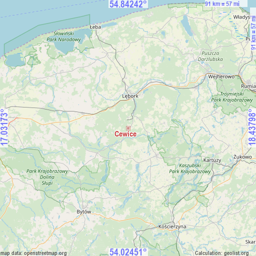
Cewice GPS coordinates[2]
54° 26' 7.836" North, 17° 44' 5.46" East
| Map corner | latitude | longitude |
|---|---|---|
| Upper-left | 54.84242°, | 17.03173° |
| Center: | 54.43551°, | 17.73485° |
| Lower-right: | 54.02451°, | 18.43798° |
| Map W x H: | 90.9×90.9 km | = 56.5×56.5mi |
| max Lat: | 54.83135° ⇑1.6% North |
| Cewice: | 54.43551° |
| min Lat: | ⇓98.4% South 49.21328° |
| min Long | Cewice | max Long |
| 14.20249° | 17.73485° | 24.03723° |
| W 22.1%⇐ | ⇒77.9% E |
Elevation
Elevation of Cewice is 159 m = 522 ft, and this is 32.4 m = 106 ft below average elevation for this country.
| Max E: |
974 m = 3196 ft | 54.9% |
| Avg. | 191.4 m = 628 ft | |
| Cewice | 159 m = 522 ft | |
Min E: |
-3 m = -10 ft | 45.1% |
See also: Poland elevation on elevation.city.
Geographical zone
Cewice is located in North temperate zone (between Tropic of Cancer and the Arctic Circle). Distance of this North polar circle is 1348.5 km =837.9 mi to North.| Distance of | km | miles | from Cewice |
|---|---|---|---|
| North Pole | 3954.4 | 2457.1 | to North |
| Arctic Circle | 1348.5 | 837.9 | to North |
| Tropic Cancer | 3446.7 | 2141.7 | to South |
| Equator | 6052.7 | 3761 | to South |


Nearby cities:
15 places around Cewice: (largest is in red/bold)
• Chmielno
26.5 km =16.5 mi,  117°
117°
• Czarna Dąbrówka
14.1 km =8.8 mi,  231°
231°
• Garcz
25.7 km =16 mi,  112°
112°
• Linia
13 km =8.1 mi,  82°
82°
• Lębork
11.6 km =7.2 mi,  4°
4°
• Maszewo Lęborskie
3.9 km =2.4 mi, 1°
• Nowa Wieś Lęborska
13.7 km =8.5 mi,  358°
358°
• Parchowo
25.8 km =16 mi,  189°
189°
• Potęgowo
16.9 km =10.5 mi,  288°
288°
• Sierakowice
14.2 km =8.8 mi,  134°
134°
• Sulęczyno
22.7 km =14.1 mi,  173°
173°
• Wicko
27.2 km =16.9 mi,  343°
343°
• Łapalice
27.4 km =17 mi, 111°
• Łupawa
20.8 km =12.9 mi,  264°
264°
• Łęczyce
19.4 km =12.1 mi,  24°
24°
Sources, notices
• [Note1] Compared only with cities in Poland existing in our database
• [Src1] Map data: © OpenStreetMap contributors (CC-BY-SA)
• [Src2] Other city data from geonames.org with taken over terms of usage.
• [Src3] Geographical zone / Annual Mean Temperature by Robert A. Rohde @ Wikipedia
