Linia geodata
Linia (Pomerania) is a populated place; located in Poland in Europe/Warsaw (GMT+2) time zone. With population of 1,405 people, there are 1950 cities with bigger population in this country. Compared to other cities in Poland, 98.6% of cities are located further ↓South; 75.9% of cities are located further →East and 50.8% of cities have higher elevation than Linia. Note1


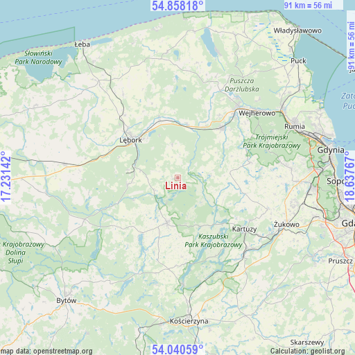
Linia GPS coordinates[2]
54° 27' 5.148" North, 17° 56' 4.344" East
| Map corner | latitude | longitude |
|---|---|---|
| Upper-left | 54.85818°, | 17.23142° |
| Center: | 54.45143°, | 17.93454° |
| Lower-right: | 54.04059°, | 18.63767° |
| Map W x H: | 90.9×90.9 km | = 56.5×56.5mi |
| max Lat: | 54.83135° ⇑1.4% North |
| Linia: | 54.45143° |
| min Lat: | ⇓98.6% South 49.21328° |
| min Long | Linia | max Long |
| 14.20249° | 17.93454° | 24.03723° |
| W 24.1%⇐ | ⇒75.9% E |
Elevation
Elevation of Linia is 170 m = 558 ft, and this is 21.4 m = 70 ft below average elevation for this country.
| Max E: |
974 m = 3196 ft | 50.8% |
| Avg. | 191.4 m = 628 ft | |
| Linia | 170 m = 558 ft | |
Min E: |
-3 m = -10 ft | 49.2% |
See also: Poland elevation on elevation.city.
Geographical zone
Linia is located in North temperate zone (between Tropic of Cancer and the Arctic Circle). Distance of this North polar circle is 1346.7 km =836.8 mi to North.| Distance of | km | miles | from Linia |
|---|---|---|---|
| North Pole | 3952.6 | 2456 | to North |
| Arctic Circle | 1346.7 | 836.8 | to North |
| Tropic Cancer | 3448.5 | 2142.8 | to South |
| Equator | 6054.4 | 3762 | to South |


Nearby cities:
15 places around Linia: (largest is in red/bold)
• Bolszewo
24.2 km =15 mi,  40°
40°
• Cewice
13 km =8.1 mi,  262°
262°
• Chmielno
17.6 km =10.9 mi,  142°
142°
• Garcz
15.8 km =9.8 mi, 136°
• Gościcino
22.2 km =13.8 mi, 39°
• Góra
23.3 km =14.5 mi,  30°
30°
• Kartuzy
21.4 km =13.3 mi,  127°
127°
• Luzino
17 km =10.6 mi, 41°
• Lębork
15.4 km =9.6 mi,  309°
309°
• Maszewo Lęborskie
13 km =8.1 mi,  279°
279°
• Nowa Wieś Lęborska
17.9 km =11.1 mi, 311°
• Sierakowice
12 km =7.5 mi,  193°
193°
• Szemud
19 km =11.8 mi,  77°
77°
• Łapalice
17.2 km =10.7 mi, 132°
• Łęczyce
16.6 km =10.3 mi,  342°
342°
Sources, notices
• [Note1] Compared only with cities in Poland existing in our database
• [Src1] Map data: © OpenStreetMap contributors (CC-BY-SA)
• [Src2] Other city data from geonames.org with taken over terms of usage.
• [Src3] Geographical zone / Annual Mean Temperature by Robert A. Rohde @ Wikipedia
