Olsztyn geodata
Olsztyn (Silesia) is a seat of a third-order administrative division; located in Poland in Europe/Warsaw (GMT+2) time zone. With population of 2,331 people, there are 1315 cities with bigger population in this country. Compared to other cities in Poland, 61.4% of cities are located further ↑North; 54.8% of cities are located further →East and 86.4% of cities have lower elevation than Olsztyn. Note1


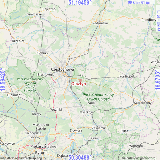
Olsztyn GPS coordinates[2]
50° 45' 6.66" North, 19° 16' 2.532" East
| Map corner | latitude | longitude |
|---|---|---|
| Upper-left | 51.19459°, | 18.56425° |
| Center: | 50.75185°, | 19.26737° |
| Lower-right: | 50.30488°, | 19.9705° |
| Map W x H: | 98.9×98.9 km | = 61.5×61.5mi |
| max Lat: | 54.83135° ⇑61.4% North |
| Olsztyn: | 50.75185° |
| min Lat: | ⇓38.6% South 49.21328° |
| min Long | Olsztyn | max Long |
| 14.20249° | 19.26737° | 24.03723° |
| W 45.2%⇐ | ⇒54.8% E |
Elevation
Elevation of Olsztyn is 298 m = 978 ft, and this is 106.6 m = 350 ft above average elevation for this country.
| Max E: |
974 m = 3196 ft | 13.6% |
| Olsztyn | 298 m 978 ft | |
| Avg. | 191.4 m = 628 ft | |
Min E: |
-3 m = -10 ft | 86.4% |
See also: Poland elevation on elevation.city.
Geographical zone
Olsztyn is located in North temperate zone (between Tropic of Cancer and the Arctic Circle). Distance of this North polar circle is 1758.1 km =1092.4 mi to North.| Distance of | km | miles | from Olsztyn |
|---|---|---|---|
| North Pole | 4364 | 2711.7 | to North |
| Arctic Circle | 1758.1 | 1092.4 | to North |
| Tropic Cancer | 3037.2 | 1887.2 | to South |
| Equator | 5643.1 | 3506.5 | to South |


Nearby cities:
15 places around Olsztyn: (largest is in red/bold)
• Choroń
7.8 km =4.8 mi,  183°
183°
• Częstochowa
11.2 km =7 mi,  296°
296°
• Huta Stara B
9.6 km =6 mi,  260°
260°
• Janów
12.1 km =7.5 mi,  105°
105°
• Jastrząb
10.9 km =6.8 mi,  213°
213°
• Kamienica Polska
13.6 km =8.5 mi,  228°
228°
• Mstów
8.7 km =5.4 mi,  8°
8°
• Poczesna
10.3 km =6.4 mi,  246°
246°
• Poraj
9 km =5.6 mi,  204°
204°
• Potok Złoty
12.6 km =7.8 mi, 113°
• Przybynów
11.5 km =7.1 mi,  162°
162°
• Rudniki
14.2 km =8.8 mi,  353°
353°
• Rędziny
12.5 km =7.8 mi,  343°
343°
• Siedlec
9.5 km =5.9 mi,  133°
133°
• Wysoka Lelowska
13.8 km =8.6 mi, 159°
Sources, notices
• [Note1] Compared only with cities in Poland existing in our database
• [Src1] Map data: © OpenStreetMap contributors (CC-BY-SA)
• [Src2] Other city data from geonames.org with taken over terms of usage.
• [Src3] Geographical zone / Annual Mean Temperature by Robert A. Rohde @ Wikipedia
