Burzenin geodata
Burzenin (Łódź Voivodeship) is a seat of a third-order administrative division; located in Poland in Europe/Warsaw (GMT+2) time zone. With population of 1,100 people, there are 2307 cities with bigger population in this country. Compared to other cities in Poland, 55.6% of cities are located further ↓South; 62.8% of cities are located further →East and 61.1% of cities have higher elevation than Burzenin. Note1


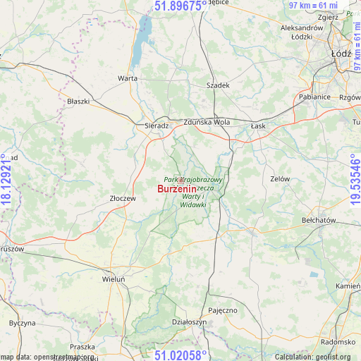
Burzenin GPS coordinates[2]
51° 27' 38.772" North, 18° 49' 56.388" East
| Map corner | latitude | longitude |
|---|---|---|
| Upper-left | 51.89675°, | 18.12921° |
| Center: | 51.46077°, | 18.83233° |
| Lower-right: | 51.02058°, | 19.53546° |
| Map W x H: | 97.4×97.4 km | = 60.5×60.5mi |
| max Lat: | 54.83135° ⇑44.4% North |
| Burzenin: | 51.46077° |
| min Lat: | ⇓55.6% South 49.21328° |
| min Long | Burzenin | max Long |
| 14.20249° | 18.83233° | 24.03723° |
| W 37.2%⇐ | ⇒62.8% E |
Elevation
Elevation of Burzenin is 144 m = 472 ft, and this is 47.4 m = 156 ft below average elevation for this country.
| Max E: |
974 m = 3196 ft | 61.1% |
| Avg. | 191.4 m = 628 ft | |
| Burzenin | 144 m = 472 ft | |
Min E: |
-3 m = -10 ft | 38.9% |
See also: Poland elevation on elevation.city.
Geographical zone
Burzenin is located in North temperate zone (between Tropic of Cancer and the Arctic Circle). Distance of this North polar circle is 1679.3 km =1043.5 mi to North.| Distance of | km | miles | from Burzenin |
|---|---|---|---|
| North Pole | 4285.2 | 2662.7 | to North |
| Arctic Circle | 1679.3 | 1043.5 | to North |
| Tropic Cancer | 3116 | 1936.2 | to South |
| Equator | 5721.9 | 3555.4 | to South |


Nearby cities:
15 places around Burzenin: (largest is in red/bold)
• Brzeźnio
15 km =9.3 mi,  284°
284°
• Buczek
23.4 km =14.5 mi,  78°
78°
• Konopnica
11.9 km =7.4 mi,  182°
182°
• Osjaków
19.3 km =12 mi,  188°
188°
• Ostrówek
20 km =12.4 mi,  226°
226°
• Rusiec
18.5 km =11.5 mi,  145°
145°
• Sieradz
16.6 km =10.3 mi,  334°
334°
• Szczerców
23.9 km =14.9 mi,  126°
126°
• Sędziejowice
14.5 km =9 mi,  69°
69°
• Widawa
8.1 km =5 mi,  107°
107°
• Wojsławice
22.2 km =13.8 mi,  16°
16°
• Wróblew
22.6 km =14 mi,  318°
318°
• Zapolice
9.8 km =6.1 mi, 21°
• Zduńska Wola
17.1 km =10.6 mi,  25°
25°
• Złoczew
16.6 km =10.3 mi,  253°
253°
Sources, notices
• [Note1] Compared only with cities in Poland existing in our database
• [Src1] Map data: © OpenStreetMap contributors (CC-BY-SA)
• [Src2] Other city data from geonames.org with taken over terms of usage.
• [Src3] Geographical zone / Annual Mean Temperature by Robert A. Rohde @ Wikipedia
