Szamotuły geodata
Szamotuły (Greater Poland) is a seat of a second-order administrative division; located in Poland in Europe/Warsaw (GMT+2) time zone. With population of 18,588 people, there are 263 cities with bigger population in this country. Compared to other cities in Poland, 78.1% of cities are located further ↓South; 89% of cities are located further →East and 90.8% of cities have higher elevation than Szamotuły. Note1


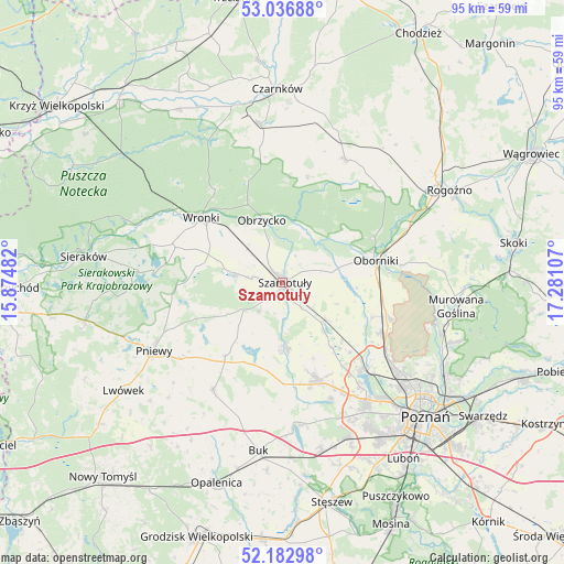
Szamotuły GPS coordinates[2]
52° 36' 43.236" North, 16° 34' 40.584" East
| Map corner | latitude | longitude |
|---|---|---|
| Upper-left | 53.03688°, | 15.87482° |
| Center: | 52.61201°, | 16.57794° |
| Lower-right: | 52.18298°, | 17.28107° |
| Map W x H: | 94.9×94.9 km | = 59×59mi |
| max Lat: | 54.83135° ⇑21.9% North |
| Szamotuły: | 52.61201° |
| min Lat: | ⇓78.1% South 49.21328° |
| min Long | Szamotuły | max Long |
| 14.20249° | 16.57794° | 24.03723° |
| W 11%⇐ | ⇒89% E |
Elevation
Elevation of Szamotuły is 71 m = 233 ft, and this is 120.4 m = 395 ft below average elevation for this country.
| Max E: |
974 m = 3196 ft | 90.8% |
| Avg. | 191.4 m = 628 ft | |
| Szamotuły | 71 m = 233 ft | |
Min E: |
-3 m = -10 ft | 9.2% |
See also: Poland elevation on elevation.city.
Geographical zone
Szamotuły is located in North temperate zone (between Tropic of Cancer and the Arctic Circle). Distance of this North polar circle is 1551.3 km =963.9 mi to North.| Distance of | km | miles | from Szamotuły |
|---|---|---|---|
| North Pole | 4157.2 | 2583.2 | to North |
| Arctic Circle | 1551.3 | 963.9 | to North |
| Tropic Cancer | 3244 | 2015.7 | to South |
| Equator | 5849.9 | 3635 | to South |


Nearby cities:
15 places around Szamotuły: (largest is in red/bold)
• Baranowo
24.2 km =15 mi,  144°
144°
• Chrzypsko Wielkie
23.7 km =14.7 mi,  274°
274°
• Duszniki
21.7 km =13.5 mi,  212°
212°
• Kaźmierz
11 km =6.8 mi,  177°
177°
• Lipnica
8 km =5 mi,  235°
235°
• Objezierze
12.5 km =7.8 mi,  93°
93°
• Oborniki
16.4 km =10.2 mi,  76°
76°
• Obrzycko
10.7 km =6.6 mi,  341°
341°
• Ostroróg
8.8 km =5.5 mi,  280°
280°
• Pamiątkowo
9.5 km =5.9 mi,  133°
133°
• Połajewo
23.3 km =14.5 mi,  26°
26°
• Rokietnica
15.8 km =9.8 mi, 134°
• Tarnowo Podgórne
17.2 km =10.7 mi,  160°
160°
• Wronki
17.2 km =10.7 mi,  309°
309°
• Złotniki
22.3 km =13.9 mi, 125°
Sources, notices
• [Note1] Compared only with cities in Poland existing in our database
• [Src1] Map data: © OpenStreetMap contributors (CC-BY-SA)
• [Src2] Other city data from geonames.org with taken over terms of usage.
• [Src3] Geographical zone / Annual Mean Temperature by Robert A. Rohde @ Wikipedia
