Obrzycko geodata
Obrzycko (Greater Poland) is a seat of a third-order administrative division; located in Poland in Europe/Warsaw (GMT+2) time zone. With population of 2,226 people, there are 1348 cities with bigger population in this country. Compared to other cities in Poland, 79.3% of cities are located further ↓South; 89.3% of cities are located further →East and 94.5% of cities have higher elevation than Obrzycko. Note1


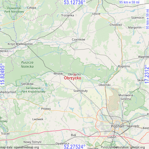
Obrzycko GPS coordinates[2]
52° 42' 12.168" North, 16° 31' 41.052" East
| Map corner | latitude | longitude |
|---|---|---|
| Upper-left | 53.12736°, | 15.82495° |
| Center: | 52.70338°, | 16.52807° |
| Lower-right: | 52.27524°, | 17.2312° |
| Map W x H: | 94.7×94.7 km | = 58.8×58.8mi |
| max Lat: | 54.83135° ⇑20.7% North |
| Obrzycko: | 52.70338° |
| min Lat: | ⇓79.3% South 49.21328° |
| min Long | Obrzycko | max Long |
| 14.20249° | 16.52807° | 24.03723° |
| W 10.7%⇐ | ⇒89.3% E |
Elevation
Elevation of Obrzycko is 47 m = 154 ft, and this is 144.4 m = 474 ft below average elevation for this country.
| Max E: |
974 m = 3196 ft | 94.5% |
| Avg. | 191.4 m = 628 ft | |
| Obrzycko | 47 m = 154 ft | |
Min E: |
-3 m = -10 ft | 5.5% |
See also: Poland elevation on elevation.city.
Geographical zone
Obrzycko is located in North temperate zone (between Tropic of Cancer and the Arctic Circle). Distance of this North polar circle is 1541.1 km =957.6 mi to North.| Distance of | km | miles | from Obrzycko |
|---|---|---|---|
| North Pole | 4147 | 2576.8 | to North |
| Arctic Circle | 1541.1 | 957.6 | to North |
| Tropic Cancer | 3254.1 | 2022 | to South |
| Equator | 5860.1 | 3641.3 | to South |


Nearby cities:
15 places around Obrzycko: (largest is in red/bold)
• Chrzypsko Wielkie
21.9 km =13.6 mi,  247°
247°
• Czarnków
22.2 km =13.8 mi,  6°
6°
• Kaźmierz
21.5 km =13.4 mi,  169°
169°
• Lipnica
15 km =9.3 mi,  192°
192°
• Lubasz
16.5 km =10.3 mi,  358°
358°
• Lutom
27.4 km =17 mi, 251°
• Objezierze
19.3 km =12 mi,  124°
124°
• Oborniki
20.3 km =12.6 mi,  107°
107°
• Ostroróg
10 km =6.2 mi,  211°
211°
• Pamiątkowo
19.6 km =12.2 mi,  148°
148°
• Połajewo
17.5 km =10.9 mi,  52°
52°
• Rokietnica
25.8 km =16 mi, 145°
• Ryczywół
23.8 km =14.8 mi,  59°
59°
• Szamotuły
10.7 km =6.6 mi,  161°
161°
• Wronki
10 km =6.2 mi,  274°
274°
Sources, notices
• [Note1] Compared only with cities in Poland existing in our database
• [Src1] Map data: © OpenStreetMap contributors (CC-BY-SA)
• [Src2] Other city data from geonames.org with taken over terms of usage.
• [Src3] Geographical zone / Annual Mean Temperature by Robert A. Rohde @ Wikipedia
