Oborniki geodata
Oborniki (Greater Poland) is a seat of a third-order administrative division; located in Poland in Europe/Warsaw (GMT+2) time zone. With population of 17,915 people, there are 275 cities with bigger population in this country. Compared to other cities in Poland, 78.6% of cities are located further ↓South; 87.1% of cities are located further →East and 93.3% of cities have higher elevation than Oborniki. Note1


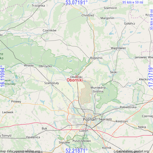
Oborniki GPS coordinates[2]
52° 38' 50.604" North, 16° 48' 50.616" East
| Map corner | latitude | longitude |
|---|---|---|
| Upper-left | 53.07191°, | 16.11094° |
| Center: | 52.64739°, | 16.81406° |
| Lower-right: | 52.21871°, | 17.51719° |
| Map W x H: | 94.9×94.9 km | = 59×59mi |
| max Lat: | 54.83135° ⇑21.4% North |
| Oborniki: | 52.64739° |
| min Lat: | ⇓78.6% South 49.21328° |
| min Long | Oborniki | max Long |
| 14.20249° | 16.81406° | 24.03723° |
| W 12.9%⇐ | ⇒87.1% E |
Elevation
Elevation of Oborniki is 58 m = 190 ft, and this is 133.4 m = 438 ft below average elevation for this country.
| Max E: |
974 m = 3196 ft | 93.3% |
| Avg. | 191.4 m = 628 ft | |
| Oborniki | 58 m = 190 ft | |
Min E: |
-3 m = -10 ft | 6.7% |
See also: Poland elevation on elevation.city.
Geographical zone
Oborniki is located in North temperate zone (between Tropic of Cancer and the Arctic Circle). Distance of this North polar circle is 1547.3 km =961.4 mi to North.| Distance of | km | miles | from Oborniki |
|---|---|---|---|
| North Pole | 4153.2 | 2580.7 | to North |
| Arctic Circle | 1547.3 | 961.4 | to North |
| Tropic Cancer | 3247.9 | 2018.2 | to South |
| Equator | 5853.8 | 3637.4 | to South |


Nearby cities:
15 places around Oborniki: (largest is in red/bold)
• Czerwonak
23.3 km =14.5 mi,  150°
150°
• Kaźmierz
21.6 km =13.4 mi,  226°
226°
• Murowana Goślina
15.5 km =9.6 mi,  121°
121°
• Objezierze
5.9 km =3.7 mi,  216°
216°
• Obrzycko
20.3 km =12.6 mi,  287°
287°
• Pamiątkowo
13.8 km =8.6 mi, 220°
• Połajewo
17.7 km =11 mi,  342°
342°
• Rogoźno
16.7 km =10.4 mi,  45°
45°
• Rokietnica
15.7 km =9.8 mi,  197°
197°
• Ryczywół
18.5 km =11.5 mi,  3°
3°
• Skoki
23.6 km =14.7 mi,  83°
83°
• Suchy Las
19.8 km =12.3 mi,  167°
167°
• Szamotuły
16.4 km =10.2 mi,  256°
256°
• Tarnowo Podgórne
22.6 km =14 mi,  206°
206°
• Złotniki
17.2 km =10.7 mi, 173°
Sources, notices
• [Note1] Compared only with cities in Poland existing in our database
• [Src1] Map data: © OpenStreetMap contributors (CC-BY-SA)
• [Src2] Other city data from geonames.org with taken over terms of usage.
• [Src3] Geographical zone / Annual Mean Temperature by Robert A. Rohde @ Wikipedia
