Miłomłyn geodata
Miłomłyn (Warmia-Masuria) is a seat of a third-order administrative division; located in Poland in Europe/Warsaw (GMT+2) time zone. With population of 2,336 people, there are 1311 cities with bigger population in this country. Compared to other cities in Poland, 92% of cities are located further ↓South; 55.7% of cities are located further ←West and 79.8% of cities have higher elevation than Miłomłyn. Note1


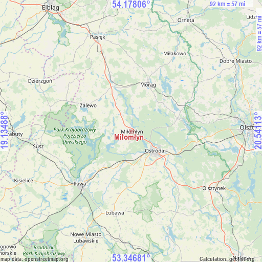
Miłomłyn GPS coordinates[2]
53° 45' 52.164" North, 19° 50' 16.8" East
| Map corner | latitude | longitude |
|---|---|---|
| Upper-left | 54.17806°, | 19.13488° |
| Center: | 53.76449°, | 19.838° |
| Lower-right: | 53.34681°, | 20.54113° |
| Map W x H: | 92.4×92.4 km | = 57.4×57.4mi |
| max Lat: | 54.83135° ⇑8% North |
| Miłomłyn: | 53.76449° |
| min Lat: | ⇓92% South 49.21328° |
| min Long | Miłomłyn | max Long |
| 14.20249° | 19.838° | 24.03723° |
| W 55.7%⇐ | ⇒44.3% E |
Elevation
Elevation of Miłomłyn is 100 m = 328 ft, and this is 91.4 m = 300 ft below average elevation for this country.
| Max E: |
974 m = 3196 ft | 79.8% |
| Avg. | 191.4 m = 628 ft | |
| Miłomłyn | 100 m = 328 ft | |
Min E: |
-3 m = -10 ft | 20.2% |
See also: Poland elevation on elevation.city.
Geographical zone
Miłomłyn is located in North temperate zone (between Tropic of Cancer and the Arctic Circle). Distance of this North polar circle is 1423.1 km =884.3 mi to North.| Distance of | km | miles | from Miłomłyn |
|---|---|---|---|
| North Pole | 4029 | 2503.5 | to North |
| Arctic Circle | 1423.1 | 884.3 | to North |
| Tropic Cancer | 3372.1 | 2095.3 | to South |
| Equator | 5978.1 | 3714.6 | to South |


Nearby cities:
15 places around Miłomłyn: (largest is in red/bold)
• Gierzwałd
29.8 km =18.5 mi,  146°
146°
• Gietrzwałd
26.3 km =16.3 mi,  94°
94°
• Grabowo
22.5 km =14 mi,  183°
183°
• Iława
25.8 km =16 mi,  223°
223°
• Jonkowo
31.8 km =19.8 mi,  77°
77°
• Lubawa
29.5 km =18.3 mi,  191°
191°
• Małdyty
18.3 km =11.4 mi,  340°
340°
• Miłakowo
31.2 km =19.4 mi,  29°
29°
• Morąg
17.9 km =11.1 mi,  18°
18°
• Ostróda
11.2 km =7 mi,  132°
132°
• Rychliki
31.8 km =19.8 mi,  320°
320°
• Susz
33.4 km =20.8 mi,  260°
260°
• Zalewo
17.7 km =11 mi,  300°
300°
• Łukta
16.8 km =10.4 mi,  74°
74°
• Świątki
32.1 km =19.9 mi,  55°
55°
Sources, notices
• [Note1] Compared only with cities in Poland existing in our database
• [Src1] Map data: © OpenStreetMap contributors (CC-BY-SA)
• [Src2] Other city data from geonames.org with taken over terms of usage.
• [Src3] Geographical zone / Annual Mean Temperature by Robert A. Rohde @ Wikipedia
