Mikołajki Pomorskie geodata
Mikołajki Pomorskie (Pomerania) is a populated place; located in Poland in Europe/Warsaw (GMT+2) time zone. With population of 1,416 people, there are 1938 cities with bigger population in this country. Compared to other cities in Poland, 92.8% of cities are located further ↓South; 56.8% of cities are located further →East and 88.9% of cities have higher elevation than Mikołajki Pomorskie. Note1
Administrative division(s):
- Level 1: Pomerania
- Level 2: Powiat sztumski
- Level 3: Mikołajki Pomorskie


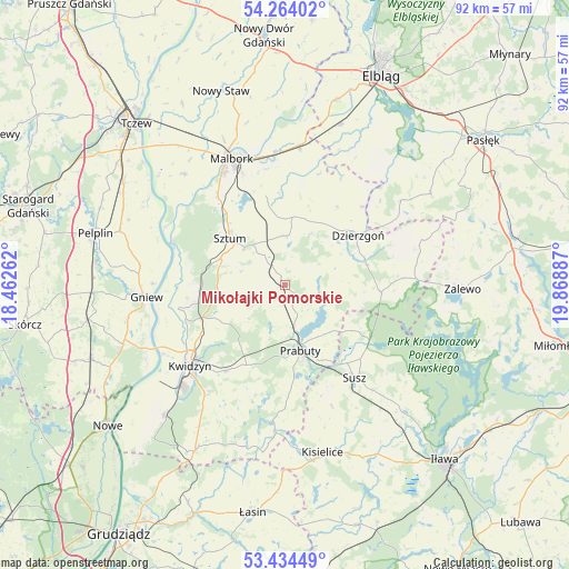
Mikołajki Pomorskie GPS coordinates[2]
53° 51' 4.716" North, 19° 9' 56.664" East
| Map corner | latitude | longitude |
|---|---|---|
| Upper-left | 54.26402°, | 18.46262° |
| Center: | 53.85131°, | 19.16574° |
| Lower-right: | 53.43449°, | 19.86887° |
| Map W x H: | 92.2×92.2 km | = 57.3×57.3mi |
| max Lat: | 54.83135° ⇑7.2% North |
| Mikołajki Pomorskie: | 53.85131° |
| min Lat: | ⇓92.8% South 49.21328° |
| min Long | Mikołajki Pomo | max Long |
| 14.20249° | 19.16574° | 24.03723° |
| W 43.2%⇐ | ⇒56.8% E |
Elevation
Elevation of Mikołajki Pomorskie is 79 m = 259 ft, and this is 112.4 m = 369 ft below average elevation for this country.
| Max E: |
974 m = 3196 ft | 88.9% |
| Avg. | 191.4 m = 628 ft | |
| Mikołajki Pomorskie | 79 m = 259 ft | |
Min E: |
-3 m = -10 ft | 11.1% |
See also: Poland elevation on elevation.city.
Geographical zone
Mikołajki Pomorskie is located in North temperate zone (between Tropic of Cancer and the Arctic Circle). Distance of this North polar circle is 1413.5 km =878.3 mi to North.| Distance of | km | miles | from Mikołajki Pomorskie |
|---|---|---|---|
| North Pole | 4019.4 | 2497.5 | to North |
| Arctic Circle | 1413.5 | 878.3 | to North |
| Tropic Cancer | 3381.8 | 2101.4 | to South |
| Equator | 5987.7 | 3720.6 | to South |


Nearby cities:
15 places around Mikołajki Pomorskie: (largest is in red/bold)
• Dzierzgoń
14.2 km =8.8 mi,  56°
56°
• Gniew
22.5 km =14 mi,  265°
265°
• Gronowo Elbląskie
27.6 km =17.1 mi,  19°
19°
• Kisielice
27.7 km =17.2 mi,  166°
166°
• Kwidzyn
20.9 km =13 mi,  227°
227°
• Malbork
22.5 km =14 mi,  336°
336°
• Markusy
26.9 km =16.7 mi,  34°
34°
• Miłoradz
24.3 km =15.1 mi,  318°
318°
• Prabuty
11 km =6.8 mi, 166°
• Ryjewo
13.5 km =8.4 mi, 266°
• Stare Pole
23 km =14.3 mi,  7°
7°
• Stary Targ
8 km =5 mi,  2°
2°
• Susz
18.6 km =11.6 mi,  143°
143°
• Sztum
11.7 km =7.3 mi,  311°
311°
• Wielkie Walichnowy
21.8 km =13.5 mi,  289°
289°
Sources, notices
• [Note1] Compared only with cities in Poland existing in our database
• [Src1] Map data: © OpenStreetMap contributors (CC-BY-SA)
• [Src2] Other city data from geonames.org with taken over terms of usage.
• [Src3] Geographical zone / Annual Mean Temperature by Robert A. Rohde @ Wikipedia
