Dobrzyca geodata
Dobrzyca (Greater Poland) is a populated place; located in Poland in Europe/Warsaw (GMT+2) time zone. With population of 3,254 people, there are 976 cities with bigger population in this country. Compared to other cities in Poland, 63% of cities are located further ↓South; 79.1% of cities are located further →East and 62.1% of cities have higher elevation than Dobrzyca. Note1


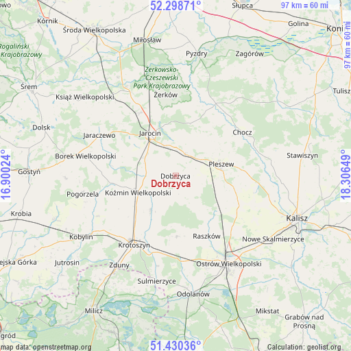
Dobrzyca GPS coordinates[2]
51° 51' 59.868" North, 17° 36' 12.096" East
| Map corner | latitude | longitude |
|---|---|---|
| Upper-left | 52.29871°, | 16.90024° |
| Center: | 51.86663°, | 17.60336° |
| Lower-right: | 51.43036°, | 18.30649° |
| Map W x H: | 96.6×96.6 km | = 60×60mi |
| max Lat: | 54.83135° ⇑37% North |
| Dobrzyca: | 51.86663° |
| min Lat: | ⇓63% South 49.21328° |
| min Long | Dobrzyca | max Long |
| 14.20249° | 17.60336° | 24.03723° |
| W 20.9%⇐ | ⇒79.1% E |
Elevation
Elevation of Dobrzyca is 142 m = 466 ft, and this is 49.4 m = 162 ft below average elevation for this country.
| Max E: |
974 m = 3196 ft | 62.1% |
| Avg. | 191.4 m = 628 ft | |
| Dobrzyca | 142 m = 466 ft | |
Min E: |
-3 m = -10 ft | 37.9% |
See also: Poland elevation on elevation.city.
Geographical zone
Dobrzyca is located in North temperate zone (between Tropic of Cancer and the Arctic Circle). Distance of this North polar circle is 1634.1 km =1015.4 mi to North.| Distance of | km | miles | from Dobrzyca |
|---|---|---|---|
| North Pole | 4240 | 2634.6 | to North |
| Arctic Circle | 1634.1 | 1015.4 | to North |
| Tropic Cancer | 3161.1 | 1964.2 | to South |
| Equator | 5767 | 3583.4 | to South |


Nearby cities:
15 places around Dobrzyca: (largest is in red/bold)
• Broniszewice
18.4 km =11.4 mi,  52°
52°
• Czermin
13.7 km =8.5 mi, 47°
• Dobieszczyzna
18.5 km =11.5 mi,  15°
15°
• Golina
9.9 km =6.2 mi,  302°
302°
• Jarocin
13.7 km =8.5 mi,  329°
329°
• Korytnica
13 km =8.1 mi,  145°
145°
• Kotlin
6.6 km =4.1 mi,  27°
27°
• Koźmin Wielkopolski
11.2 km =7 mi,  246°
246°
• Moszczanka
18.9 km =11.7 mi, 150°
• Pleszew
12.9 km =8 mi,  75°
75°
• Raszków
18.5 km =11.5 mi, 152°
• Rozdrażew
11.6 km =7.2 mi,  215°
215°
• Sośnica
5.3 km =3.3 mi,  96°
96°
• Witaszyce
8.8 km =5.5 mi,  341°
341°
• Zakrzew
7.9 km =4.9 mi,  324°
324°
Sources, notices
• [Note1] Compared only with cities in Poland existing in our database
• [Src1] Map data: © OpenStreetMap contributors (CC-BY-SA)
• [Src2] Other city data from geonames.org with taken over terms of usage.
• [Src3] Geographical zone / Annual Mean Temperature by Robert A. Rohde @ Wikipedia
