Kotlin geodata
Kotlin (Greater Poland) is a seat of a third-order administrative division; located in Poland in Europe/Warsaw (GMT+2) time zone. With population of 3,416 people, there are 931 cities with bigger population in this country. Compared to other cities in Poland, 64.1% of cities are located further ↓South; 78.8% of cities are located further →East and 69.3% of cities have higher elevation than Kotlin. Note1


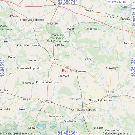
Kotlin GPS coordinates[2]
51° 55' 8.868" North, 17° 38' 53.7" East
| Map corner | latitude | longitude |
|---|---|---|
| Upper-left | 52.35071°, | 16.94513° |
| Center: | 51.91913°, | 17.64825° |
| Lower-right: | 51.48336°, | 18.35138° |
| Map W x H: | 96.4×96.4 km | = 59.9×59.9mi |
| max Lat: | 54.83135° ⇑35.9% North |
| Kotlin: | 51.91913° |
| min Lat: | ⇓64.1% South 49.21328° |
| min Long | Kotlin | max Long |
| 14.20249° | 17.64825° | 24.03723° |
| W 21.2%⇐ | ⇒78.8% E |
Elevation
Elevation of Kotlin is 122 m = 400 ft, and this is 69.4 m = 228 ft below average elevation for this country.
| Max E: |
974 m = 3196 ft | 69.3% |
| Avg. | 191.4 m = 628 ft | |
| Kotlin | 122 m = 400 ft | |
Min E: |
-3 m = -10 ft | 30.7% |
See also: Poland elevation on elevation.city.
Geographical zone
Kotlin is located in North temperate zone (between Tropic of Cancer and the Arctic Circle). Distance of this North polar circle is 1628.3 km =1011.8 mi to North.| Distance of | km | miles | from Kotlin |
|---|---|---|---|
| North Pole | 4234.2 | 2631 | to North |
| Arctic Circle | 1628.3 | 1011.8 | to North |
| Tropic Cancer | 3166.9 | 1967.8 | to South |
| Equator | 5772.9 | 3587.1 | to South |


Nearby cities:
15 places around Kotlin: (largest is in red/bold)
• Broniszewice
12.7 km =7.9 mi,  65°
65°
• Chocz
16.5 km =10.3 mi, 67°
• Czermin
7.8 km =4.8 mi,  63°
63°
• Dobieszczyzna
12.1 km =7.5 mi,  8°
8°
• Dobrzyca
6.6 km =4.1 mi,  207°
207°
• Gizałki
16 km =9.9 mi,  31°
31°
• Golina
11.4 km =7.1 mi,  267°
267°
• Jarocin
11.6 km =7.2 mi,  300°
300°
• Korytnica
17.1 km =10.6 mi,  165°
165°
• Koźmin Wielkopolski
16.8 km =10.4 mi,  232°
232°
• Pleszew
9.7 km =6 mi,  105°
105°
• Sośnica
6.8 km =4.2 mi,  160°
160°
• Tomice
17.5 km =10.9 mi,  20°
20°
• Witaszyce
6.4 km =4 mi,  292°
292°
• Zakrzew
7.7 km =4.8 mi, 274°
Sources, notices
• [Note1] Compared only with cities in Poland existing in our database
• [Src1] Map data: © OpenStreetMap contributors (CC-BY-SA)
• [Src2] Other city data from geonames.org with taken over terms of usage.
• [Src3] Geographical zone / Annual Mean Temperature by Robert A. Rohde @ Wikipedia
