Sośnica geodata
Sośnica (Greater Poland) is a populated place; located in Poland in Europe/Warsaw (GMT+2) time zone. With population of 585 people, there are 3323 cities with bigger population in this country. Compared to other cities in Poland, 62.9% of cities are located further ↓South; 78.5% of cities are located further →East and 65.2% of cities have higher elevation than Sośnica. Note1


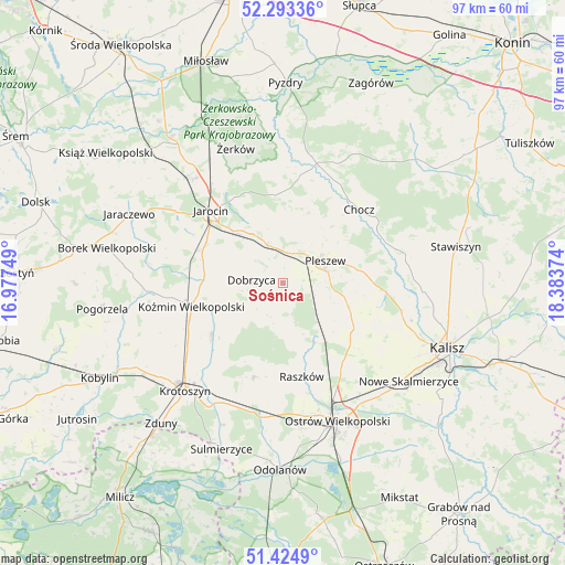
Sośnica GPS coordinates[2]
51° 51' 40.428" North, 17° 40' 50.196" East
| Map corner | latitude | longitude |
|---|---|---|
| Upper-left | 52.29336°, | 16.97749° |
| Center: | 51.86123°, | 17.68061° |
| Lower-right: | 51.4249°, | 18.38374° |
| Map W x H: | 96.6×96.6 km | = 60×60mi |
| max Lat: | 54.83135° ⇑37.1% North |
| Sośnica: | 51.86123° |
| min Lat: | ⇓62.9% South 49.21328° |
| min Long | Sośnica | max Long |
| 14.20249° | 17.68061° | 24.03723° |
| W 21.5%⇐ | ⇒78.5% E |
Elevation
Elevation of Sośnica is 132 m = 433 ft, and this is 59.4 m = 195 ft below average elevation for this country.
| Max E: |
974 m = 3196 ft | 65.2% |
| Avg. | 191.4 m = 628 ft | |
| Sośnica | 132 m = 433 ft | |
Min E: |
-3 m = -10 ft | 34.8% |
See also: Poland elevation on elevation.city.
Geographical zone
Sośnica is located in North temperate zone (between Tropic of Cancer and the Arctic Circle). Distance of this North polar circle is 1634.7 km =1015.8 mi to North.| Distance of | km | miles | from Sośnica |
|---|---|---|---|
| North Pole | 4240.6 | 2635 | to North |
| Arctic Circle | 1634.7 | 1015.8 | to North |
| Tropic Cancer | 3160.5 | 1963.8 | to South |
| Equator | 5766.4 | 3583.1 | to South |


Nearby cities:
15 places around Sośnica: (largest is in red/bold)
• Broniszewice
15 km =9.3 mi,  38°
38°
• Czermin
11 km =6.8 mi,  25°
25°
• Dobrzyca
5.3 km =3.3 mi,  276°
276°
• Golina
14.8 km =9.2 mi,  293°
293°
• Gołuchów
17.3 km =10.7 mi,  94°
94°
• Korytnica
10.3 km =6.4 mi,  168°
168°
• Kotlin
6.8 km =4.2 mi,  340°
340°
• Koźmin Wielkopolski
16 km =9.9 mi,  256°
256°
• Moszczanka
16.3 km =10.1 mi, 166°
• Pleszew
8.2 km =5.1 mi,  61°
61°
• Raszków
16.2 km =10.1 mi, 168°
• Rozdrażew
14.9 km =9.3 mi,  233°
233°
• Sobótka
15.2 km =9.4 mi,  126°
126°
• Witaszyce
12.1 km =7.5 mi,  317°
317°
• Zakrzew
12.1 km =7.5 mi,  305°
305°
Sources, notices
• [Note1] Compared only with cities in Poland existing in our database
• [Src1] Map data: © OpenStreetMap contributors (CC-BY-SA)
• [Src2] Other city data from geonames.org with taken over terms of usage.
• [Src3] Geographical zone / Annual Mean Temperature by Robert A. Rohde @ Wikipedia
