Pogórze geodata
Pogórze (Pomerania) is a populated place; located in Poland in Europe/Warsaw (GMT+2) time zone. With population of 1,123 people, there are 2275 cities with bigger population in this country. Compared to other cities in Poland, 98.9% of cities are located further ↓South; 68.4% of cities are located further →East and 89.6% of cities have higher elevation than Pogórze. Note1


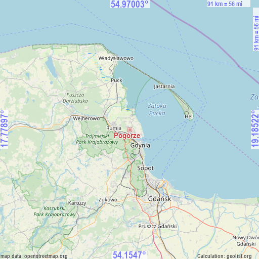
Pogórze GPS coordinates[2]
54° 33' 51.84" North, 18° 28' 55.524" East
| Map corner | latitude | longitude |
|---|---|---|
| Upper-left | 54.97003°, | 17.77897° |
| Center: | 54.5644°, | 18.48209° |
| Lower-right: | 54.1547°, | 19.18522° |
| Map W x H: | 90.7×90.7 km | = 56.4×56.4mi |
| max Lat: | 54.83135° ⇑1.1% North |
| Pogórze: | 54.5644° |
| min Lat: | ⇓98.9% South 49.21328° |
| min Long | Pogórze | max Long |
| 14.20249° | 18.48209° | 24.03723° |
| W 31.6%⇐ | ⇒68.4% E |
Elevation
Elevation of Pogórze is 77 m = 253 ft, and this is 114.4 m = 375 ft below average elevation for this country.
| Max E: |
974 m = 3196 ft | 89.6% |
| Avg. | 191.4 m = 628 ft | |
| Pogórze | 77 m = 253 ft | |
Min E: |
-3 m = -10 ft | 10.4% |
See also: Poland elevation on elevation.city.
Geographical zone
Pogórze is located in North temperate zone (between Tropic of Cancer and the Arctic Circle). Distance of this North polar circle is 1334.2 km =829 mi to North.| Distance of | km | miles | from Pogórze |
|---|---|---|---|
| North Pole | 3940.1 | 2448.3 | to North |
| Arctic Circle | 1334.2 | 829 | to North |
| Tropic Cancer | 3461.1 | 2150.6 | to South |
| Equator | 6067 | 3769.9 | to South |


Nearby cities:
15 places around Pogórze: (largest is in red/bold)
• Bojano
12.1 km =7.5 mi,  211°
211°
• Chwaszczyno
14 km =8.7 mi,  196°
196°
• Dębogórze
3.3 km =2.1 mi,  332°
332°
• Gdynia
6 km =3.7 mi,  147°
147°
• Koleczkowo
12.5 km =7.8 mi,  225°
225°
• Kosakowo
2.8 km =1.7 mi,  3°
3°
• Mosty
5.4 km =3.4 mi,  9°
9°
• Mrzezino
10.5 km =6.5 mi,  341°
341°
• Pierwoszyno
3.8 km =2.4 mi,  17°
17°
• Reda
9.8 km =6.1 mi,  297°
297°
• Rekowo Dolne
10.7 km =6.6 mi,  314°
314°
• Rewa
7.8 km =4.8 mi, 12°
• Rumia
6.1 km =3.8 mi,  276°
276°
• Wielki Kack
10.8 km =6.7 mi,  177°
177°
• Żelistrzewo
13.3 km =8.3 mi, 341°
Sources, notices
• [Note1] Compared only with cities in Poland existing in our database
• [Src1] Map data: © OpenStreetMap contributors (CC-BY-SA)
• [Src2] Other city data from geonames.org with taken over terms of usage.
• [Src3] Geographical zone / Annual Mean Temperature by Robert A. Rohde @ Wikipedia
