Wejherowo geodata
Wejherowo (Pomerania) is a seat of a second-order administrative division; located in Poland in Europe/Warsaw (GMT+2) time zone. With population of 46,820 people, there are 112 cities with bigger population in this country. Compared to other cities in Poland, 99.2% of cities are located further ↓South; 72% of cities are located further →East and 96.5% of cities have higher elevation than Wejherowo. Note1


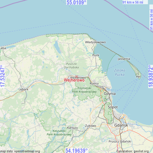
Wejherowo GPS coordinates[2]
54° 36' 20.448" North, 18° 14' 8.124" East
| Map corner | latitude | longitude |
|---|---|---|
| Upper-left | 55.0109°, | 17.53247° |
| Center: | 54.60568°, | 18.23559° |
| Lower-right: | 54.19639°, | 18.93872° |
| Map W x H: | 90.6×90.6 km | = 56.3×56.3mi |
| max Lat: | 54.83135° ⇑0.8% North |
| Wejherowo: | 54.60568° |
| min Lat: | ⇓99.2% South 49.21328° |
| min Long | Wejherowo | max Long |
| 14.20249° | 18.23559° | 24.03723° |
| W 28%⇐ | ⇒72% E |
Elevation
Elevation of Wejherowo is 27 m = 89 ft, and this is 164.4 m = 539 ft below average elevation for this country.
| Max E: |
974 m = 3196 ft | 96.5% |
| Avg. | 191.4 m = 628 ft | |
| Wejherowo | 27 m = 89 ft | |
Min E: |
-3 m = -10 ft | 3.5% |
See also: Wejherowo elevation on elevation.city.
Geographical zone
Wejherowo is located in North temperate zone (between Tropic of Cancer and the Arctic Circle). Distance of this North polar circle is 1329.6 km =826.2 mi to North.| Distance of | km | miles | from Wejherowo |
|---|---|---|---|
| North Pole | 3935.5 | 2445.4 | to North |
| Arctic Circle | 1329.6 | 826.2 | to North |
| Tropic Cancer | 3465.7 | 2153.5 | to South |
| Equator | 6071.6 | 3772.7 | to South |


Nearby cities:
15 places around Wejherowo: (largest is in red/bold)
• Bolszewo
4.1 km =2.5 mi,  289°
289°
• Dębogórze
14.5 km =9 mi,  96°
96°
• Gościcino
5.2 km =3.2 mi,  268°
268°
• Góra
8.2 km =5.1 mi, 291°
• Koleczkowo
15 km =9.3 mi,  152°
152°
• Kosakowo
16.2 km =10.1 mi, 96°
• Luzino
9.3 km =5.8 mi,  241°
241°
• Mrzezino
13.6 km =8.5 mi,  66°
66°
• Orle
5.7 km =3.5 mi,  312°
312°
• Reda
7.2 km =4.5 mi,  90°
90°
• Rekowo Dolne
8.7 km =5.4 mi, 70°
• Rumia
10.6 km =6.6 mi,  111°
111°
• Rybno
13 km =8.1 mi, 312°
• Szemud
13.2 km =8.2 mi,  183°
183°
• Żelistrzewo
14.2 km =8.8 mi,  55°
55°
Sources, notices
• [Note1] Compared only with cities in Poland existing in our database
• [Src1] Map data: © OpenStreetMap contributors (CC-BY-SA)
• [Src2] Other city data from geonames.org with taken over terms of usage.
• [Src3] Geographical zone / Annual Mean Temperature by Robert A. Rohde @ Wikipedia
