Rumia geodata
Rumia (Pomerania) is a seat of a third-order administrative division; located in Poland in Europe/Warsaw (GMT+2) time zone. With population of 44,791 people, there are 114 cities with bigger population in this country. Compared to other cities in Poland, 99% of cities are located further ↓South; 70% of cities are located further →East and 96.8% of cities have higher elevation than Rumia. Note1


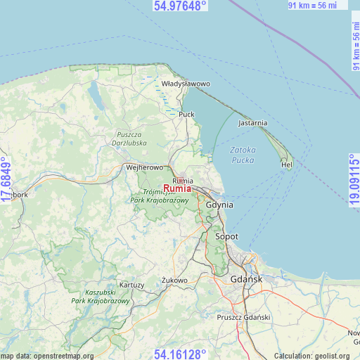
Rumia GPS coordinates[2]
54° 34' 15.312" North, 18° 23' 16.872" East
| Map corner | latitude | longitude |
|---|---|---|
| Upper-left | 54.97648°, | 17.6849° |
| Center: | 54.57092°, | 18.38802° |
| Lower-right: | 54.16128°, | 19.09115° |
| Map W x H: | 90.6×90.6 km | = 56.3×56.3mi |
| max Lat: | 54.83135° ⇑1% North |
| Rumia: | 54.57092° |
| min Lat: | ⇓99% South 49.21328° |
| min Long | Rumia | max Long |
| 14.20249° | 18.38802° | 24.03723° |
| W 30%⇐ | ⇒70% E |
Elevation
Elevation of Rumia is 23 m = 75 ft, and this is 168.4 m = 552 ft below average elevation for this country.
| Max E: |
974 m = 3196 ft | 96.8% |
| Avg. | 191.4 m = 628 ft | |
| Rumia | 23 m = 75 ft | |
Min E: |
-3 m = -10 ft | 3.2% |
See also: Rumia elevation on elevation.city.
Geographical zone
Rumia is located in North temperate zone (between Tropic of Cancer and the Arctic Circle). Distance of this North polar circle is 1333.5 km =828.6 mi to North.| Distance of | km | miles | from Rumia |
|---|---|---|---|
| North Pole | 3939.3 | 2447.8 | to North |
| Arctic Circle | 1333.5 | 828.6 | to North |
| Tropic Cancer | 3461.8 | 2151.1 | to South |
| Equator | 6067.7 | 3770.3 | to South |


Nearby cities:
15 places around Rumia: (largest is in red/bold)
• Bojano
11.1 km =6.9 mi,  181°
181°
• Dębogórze
5.1 km =3.2 mi,  64°
64°
• Gdynia
10.9 km =6.8 mi,  121°
121°
• Koleczkowo
9.8 km =6.1 mi,  196°
196°
• Kosakowo
6.6 km =4.1 mi,  71°
71°
• Mosty
8.3 km =5.2 mi, 56°
• Mrzezino
9.6 km =6 mi,  16°
16°
• Pierwoszyno
7.8 km =4.8 mi, 68°
• Pogórze
6.1 km =3.8 mi,  96°
96°
• Reda
4.6 km =2.9 mi,  325°
325°
• Rekowo Dolne
6.9 km =4.3 mi,  346°
346°
• Rewa
10.4 km =6.5 mi,  48°
48°
• Wejherowo
10.6 km =6.6 mi,  291°
291°
• Wielki Kack
13.2 km =8.2 mi,  150°
150°
• Żelistrzewo
12 km =7.5 mi,  9°
9°
Sources, notices
• [Note1] Compared only with cities in Poland existing in our database
• [Src1] Map data: © OpenStreetMap contributors (CC-BY-SA)
• [Src2] Other city data from geonames.org with taken over terms of usage.
• [Src3] Geographical zone / Annual Mean Temperature by Robert A. Rohde @ Wikipedia
