Oława geodata
Oława (Lower Silesia) is a populated place; located in Poland in Europe/Warsaw (GMT+2) time zone. With population of 30,898 people, there are 159 cities with bigger population in this country. Compared to other cities in Poland, 56.5% of cities are located further ↑North; 81.4% of cities are located further →East and 66.4% of cities have higher elevation than Oława. Note1


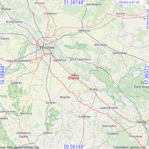
Oława GPS coordinates[2]
50° 56' 47.76" North, 17° 17' 33.36" East
| Map corner | latitude | longitude |
|---|---|---|
| Upper-left | 51.38749°, | 16.58948° |
| Center: | 50.9466°, | 17.2926° |
| Lower-right: | 50.50149°, | 17.99573° |
| Map W x H: | 98.5×98.5 km | = 61.2×61.2mi |
| max Lat: | 54.83135° ⇑56.5% North |
| Oława: | 50.9466° |
| min Lat: | ⇓43.5% South 49.21328° |
| min Long | Oława | max Long |
| 14.20249° | 17.2926° | 24.03723° |
| W 18.6%⇐ | ⇒81.4% E |
Elevation
Elevation of Oława is 129 m = 423 ft, and this is 62.4 m = 205 ft below average elevation for this country.
| Max E: |
974 m = 3196 ft | 66.4% |
| Avg. | 191.4 m = 628 ft | |
| Oława | 129 m = 423 ft | |
Min E: |
-3 m = -10 ft | 33.6% |
See also: Poland elevation on elevation.city.
Geographical zone
Oława is located in North temperate zone (between Tropic of Cancer and the Arctic Circle). Distance of this North polar circle is 1736.4 km =1078.9 mi to North.| Distance of | km | miles | from Oława |
|---|---|---|---|
| North Pole | 4342.3 | 2698.2 | to North |
| Arctic Circle | 1736.4 | 1078.9 | to North |
| Tropic Cancer | 3058.8 | 1900.6 | to South |
| Equator | 5664.7 | 3519.9 | to South |


Nearby cities:
15 places around Oława: (largest is in red/bold)
• Brzeg
15.5 km =9.6 mi,  127°
127°
• Bystrzyca
7.5 km =4.7 mi,  78°
78°
• Czernica
11.6 km =7.2 mi,  343°
343°
• Domaniów
12.8 km =8 mi,  242°
242°
• Gajków
14.6 km =9.1 mi,  329°
329°
• Jelcz
8.5 km =5.3 mi,  13°
13°
• Jelcz Laskowice
8.5 km =5.3 mi, 11°
• Minkowice Oławskie
14.3 km =8.9 mi,  55°
55°
• Miłoszyce
11.6 km =7.2 mi, 7°
• Osiek
6.6 km =4.1 mi,  180°
180°
• Ratowice
9.7 km =6 mi,  351°
351°
• Siechnice
14 km =8.7 mi,  313°
313°
• Skarbimierz Osiedle
14.3 km =8.9 mi,  141°
141°
• Wierzbno
8 km =5 mi,  262°
262°
• Święta Katarzyna
15.3 km =9.5 mi, 305°
Sources, notices
• [Note1] Compared only with cities in Poland existing in our database
• [Src1] Map data: © OpenStreetMap contributors (CC-BY-SA)
• [Src2] Other city data from geonames.org with taken over terms of usage.
• [Src3] Geographical zone / Annual Mean Temperature by Robert A. Rohde @ Wikipedia
